IMAGES TAKEN NEAR TO
Fortwilliam Park, BELFAST, BT15 4AT
Introduction
This page details the photographs taken nearby to Fortwilliam Park, BT15 4AT by members of the Geograph project.
The Geograph project started in 2005 with the aim of publishing, organising and preserving representative images for every square kilometre of Great Britain, Ireland and the Isle of Man.

There are currently over 7.5m images from over14,400 individuals and you can help contribute to the project by visiting https://www.geograph.org.uk
Image Map
Images are licensed for reuse under creativecommons.org/licenses/by-sa/2.0
Notes
- Clicking on the map will re-center to the selected point.
- The higher the marker number, the further away the image location is from the centre of the postcode.
Image Listing (42 Images Found)
Images are licensed for reuse under creativecommons.org/licenses/by-sa/2.0
Image
Details
Distance
1
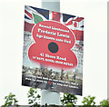
Second Lieutenant Frederic Lewis memorial plaque, Shore Road, Belfast (June 2016)
A memorial plaque, attached to a lamppost on the Shore Road, opposite Fortwilliam gates Image It reads “Second Lieutenant Frederic Lewis age unknown unto God 41 Shore Road 10th Batt. Royal Irish Rifles” – a victim of WW1. The 1918 street directory shows “41 [Shore Road]. Skegoniel Post Office - Mrs. Lewis, sub-postmistress”.
Image: © Albert Bridge
Taken: 16 Jun 2016
0.03 miles
2
Recycling bin, Belfast (June 2016)
A Community Clothing Bank recycling bin on the Shore Road. Fortwilliam gates Image are in the background.
Image: © Albert Bridge
Taken: 16 Jun 2016
0.03 miles
3
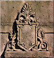
Fortwilliam gates, Belfast (3)
A shield on this gate Image
Image: © Albert Bridge
Taken: 27 Apr 2011
0.03 miles
4
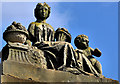
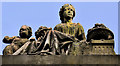
Fortwilliam gates, Belfast (2)
Traditional Belfast embellishment of the top of this gate Image including urns and a cherub.
Image: © Albert Bridge
Taken: 27 Apr 2011
0.03 miles
5
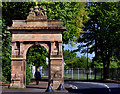
Fortwilliam gates, Belfast (1)
The gate pillar on the south western side at the Shore Road end.
Image: © Albert Bridge
Taken: 27 Apr 2011
0.03 miles
6
Fortwilliam gates, Belfast (4)
The two Shore Road pillars seen from Fortwilliam Park.
Image: © Albert Bridge
Taken: 27 Apr 2011
0.03 miles
7
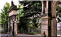
Fortwilliam gates, Belfast (5)
Embellishment, on the north eastern pillar, similar to that on the south western side Image
Image: © Albert Bridge
Taken: 27 Apr 2011
0.03 miles
8
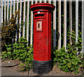
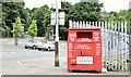
Pillar box, Belfast
GVIIR pillar box on the Shore Road, close to Fortwilliam Park.
Image: © Albert Bridge
Taken: 27 Apr 2011
0.04 miles
9
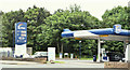
Emo petrol station, Belfast (June 2016)
An Emo http://www.geograph.org.uk/of/Emo+petrol petrol station on the Shore Road.
Image: © Albert Bridge
Taken: 16 Jun 2016
0.06 miles
10
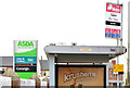
"Safeway" bus stop, Belfast
Once upon a time there was a locally-owned chain (resembling Woolworths but selling food etc) called FA Wellworth & Co. To the best of my knowledge it originated in Enniskillen in the 1950’s and remained independent until the 1990’s when it became part of a much bigger group. By 1997 the larger supermarkets were trading under the Safeway branding. Safeways was acquired by Morrisons in 2004 who sold the NI stores to Asda in 2005 – the current owner. The “Safeway” name still adorns this bus stop, at the former “Wellworths”, on the Shore Road.
Image: © Albert Bridge
Taken: 9 Apr 2014
0.07 miles