1
Fortwilliam gospel hall, Belfast
Gospel hall, in the modern style, on the Shore Road opposite York Parade.
Image: © Albert Bridge
Taken: 27 Apr 2011
0.09 miles
2
"March for Jesus" poster, Shore Road, Belfast (July 2018)
“March for Jesus” poster, on a relay box, opposite Lidl
Image
Image: © Albert Bridge
Taken: 15 Jul 2018
0.09 miles
3
Translink Railcar Depot
The 170 metre long, 30 metre wide and 10 metre high train cleaning and stabling facility was designed for the purpose of cleaning and maintaining Translink’s new rolling stock (http://www.rpparchitects.co.uk/portfolio/portfolio/fortwilliam-train-cleaning-facility/ RPP Architects).
Image: © David Dixon
Taken: 26 May 2017
0.09 miles
4
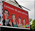
Coca-Cola 125th anniversary poster, Belfast
A poster on the Shore Road, opposite Fortwilliam Crescent, marking the 125th anniversary of Coca-Cola – a product first produced in 1886 by one John Pemberton. See also
Image,
Image,
Image and
Image
For another poster continue to
Image
Image: © Albert Bridge
Taken: 27 Apr 2011
0.10 miles
5
Lidl, Shore Road, Belfast (July 2018)
Lidl supermarket at 196 Shore Road.
Image: © Albert Bridge
Taken: 15 Jul 2018
0.12 miles
6
"Safeway" bus stop, Belfast
Once upon a time there was a locally-owned chain (resembling Woolworths but selling food etc) called FA Wellworth & Co. To the best of my knowledge it originated in Enniskillen in the 1950’s and remained independent until the 1990’s when it became part of a much bigger group. By 1997 the larger supermarkets were trading under the Safeway branding. Safeways was acquired by Morrisons in 2004 who sold the NI stores to Asda in 2005 – the current owner. The “Safeway” name still adorns this bus stop, at the former “Wellworths”, on the Shore Road.
Image: © Albert Bridge
Taken: 9 Apr 2014
0.12 miles
7
Potter Cowan warehouse seen from the M2
Image: © Colin Pyle
Taken: 29 Jul 2022
0.12 miles
8
Motorway Sidings
The Motorway Sidings at Fortwilliam. This area previously contained a number of railway lines where NIR used to store withdrawn departmental rolling stock.
In this photo, the area is being cleared in preparation for the construction of the new NIR Railcar Depot.
Image: © Wilson Adams
Taken: 27 Aug 2004
0.12 miles
9
Safety barrier replacement, M2, Belfast (2)
See
Image The coned-off area on the southern side of the roundabout.
Image: © Albert Bridge
Taken: 16 Jul 2011
0.13 miles
10
Seaview: Home of Crusaders F.C.
Crusaders are a north Belfast outfit - based at Seaview on the Shore Road, adjacent to the Larne/'Derry railway line and the M2 motorway.
Image: © Dean Molyneaux
Taken: 12 Sep 2009
0.14 miles


