IMAGES TAKEN NEAR TO
Seabourne Parade, BELFAST, BT15 3NP
Introduction
This page details the photographs taken nearby to Seabourne Parade, BT15 3NP by members of the Geograph project.
The Geograph project started in 2005 with the aim of publishing, organising and preserving representative images for every square kilometre of Great Britain, Ireland and the Isle of Man.

There are currently over 7.5m images from over14,400 individuals and you can help contribute to the project by visiting https://www.geograph.org.uk
Image Map
Images are licensed for reuse under creativecommons.org/licenses/by-sa/2.0
Notes
- Clicking on the map will re-center to the selected point.
- The higher the marker number, the further away the image location is from the centre of the postcode.
Image Listing (4 Images Found)
Images are licensed for reuse under creativecommons.org/licenses/by-sa/2.0
Image
Details
Distance
1
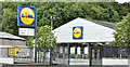
Lidl, Shore Road, Belfast (July 2018)
Lidl supermarket at 196 Shore Road.
Image: © Albert Bridge
Taken: 15 Jul 2018
0.22 miles
2
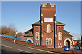
Seaview Presbyterian church, Belfast
A redbrick church, at the corner of the Shore Road and the steep Premier Drive (foreground). The following is a quotation from the Presbyterian Church website: “The church hall was built and opened on 31st October 1936 whilst the church itself was erected later and officially dedicated on 5th October 1940. Slight damage was caused during the blitz in 1941 and new halls and improvements were made during the 1950s”.
Image: © Albert Bridge
Taken: 6 Feb 2014
0.23 miles
3
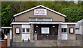
Fortwilliam gospel hall, Belfast
Gospel hall, in the modern style, on the Shore Road opposite York Parade.
Image: © Albert Bridge
Taken: 27 Apr 2011
0.24 miles
4
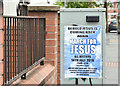
"March for Jesus" poster, Shore Road, Belfast (July 2018)
“March for Jesus” poster, on a relay box, opposite Lidl Image
Image: © Albert Bridge
Taken: 15 Jul 2018
0.24 miles