IMAGES TAKEN NEAR TO
Jellicoe Avenue, BELFAST, BT15 3FZ
Introduction
This page details the photographs taken nearby to Jellicoe Avenue, BT15 3FZ by members of the Geograph project.
The Geograph project started in 2005 with the aim of publishing, organising and preserving representative images for every square kilometre of Great Britain, Ireland and the Isle of Man.

There are currently over 7.5m images from over14,400 individuals and you can help contribute to the project by visiting https://www.geograph.org.uk
Image Map
Images are licensed for reuse under creativecommons.org/licenses/by-sa/2.0
Notes
- Clicking on the map will re-center to the selected point.
- The higher the marker number, the further away the image location is from the centre of the postcode.
Image Listing (4 Images Found)
Images are licensed for reuse under creativecommons.org/licenses/by-sa/2.0
Image
Details
Distance
1
![Antrim Road Waterworks [1]](https://s2.geograph.org.uk/photos/49/79/497906_d6306573_120x120.jpg)
Antrim Road Waterworks [1]
Antrim Road Waterworks - this is the lower pond looking towards Cave Hill.
The Waterworks, as the name suggests, was the source of Belfast`s water supply in the mid 1800s. The growing city soon outpaced supply however and the site was eventually used for recreation. It became a public park in the 1950s.
Image: © Rossographer
Taken: 18 Jul 2007
0.15 miles
2
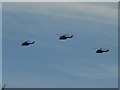
Three helicopters
Adopting a similar formation to that of the swans we were to see at the same spot the following day (see Image), this would have been around 11 o'clock on Remembrance Sunday, so the flypast may have been connected with the activities at the cenotaph (Image).
Image: © Chris Downer
Taken: 11 Nov 2007
0.23 miles
3
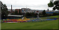
Playpark, Grove Playing Fields
Playpark on the edge of Grove Playing Fields in north Belfast.
Image: © Rossographer
Taken: 19 Jun 2009
0.23 miles
4
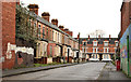
Clanchattan Street, Belfast
A street, built towards the end of the 19th century, running from the Limestone Road Image to Parkside Gardens (background). Now blocked up pending redevelopment. This link http://en.wikipedia.org/wiki/Chattan_Confederation might explain the name.
Image: © Albert Bridge
Taken: 21 Nov 2011
0.24 miles