IMAGES TAKEN NEAR TO
Alexandra Park Avenue, BELFAST, BT15 3ES
Introduction
This page details the photographs taken nearby to Alexandra Park Avenue, BT15 3ES by members of the Geograph project.
The Geograph project started in 2005 with the aim of publishing, organising and preserving representative images for every square kilometre of Great Britain, Ireland and the Isle of Man.

There are currently over 7.5m images from over14,400 individuals and you can help contribute to the project by visiting https://www.geograph.org.uk
Image Map
Images are licensed for reuse under creativecommons.org/licenses/by-sa/2.0
Notes
- Clicking on the map will re-center to the selected point.
- The higher the marker number, the further away the image location is from the centre of the postcode.
Image Listing (29 Images Found)
Images are licensed for reuse under creativecommons.org/licenses/by-sa/2.0
Image
Details
Distance
1
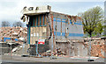
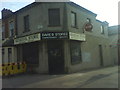
The remains of the Grove Baths, Belfast (2013-2)
See Image One small but recognisable part is still standing.
Image: © Albert Bridge
Taken: 5 May 2013
0.16 miles
2
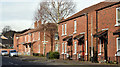
Parkmount Street, Belfast - February 2016(2)
See Image Replacement social housing, on the northern side of Parkmount Street, to the west of North Queen Street.
Image: © Albert Bridge
Taken: 24 Feb 2016
0.16 miles
3
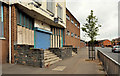
Former Grove Baths, Belfast (2)
The (closed) entrance, from York Road, to the former Grove Baths Image Demolition started on 8 February 2013. Image and Image show two views in May 2013.
Image: © Albert Bridge
Taken: 3 Aug 2011
0.16 miles
4
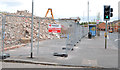
The remains of the Grove Baths, Belfast (2013-1)
See Image (August 2011). The demolition of this building, which seems to have been mostly reinforced concrete, is almost complete. This view is from Grove Place. Continue to Image
Image: © Albert Bridge
Taken: 5 May 2013
0.16 miles
6
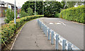
Park access road, Belfast
Not shown on the 1:12,000 OS street map, this road runs from the Grove playing fields to North Queen Street (left).
Image: © Albert Bridge
Taken: 3 Aug 2011
0.17 miles
7
Former Grove Baths, Belfast
My knowledge of north Belfast is extremely limited so no potted history. I can, however, say that the name “Grove” seems to come from The Grove and the Grove Lodge, two Victorian properties in the immediate area. Demolished on 8 February 2013. See also Image
Image: © Albert Bridge
Taken: 15 Oct 2010
0.17 miles
8
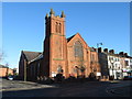
Alexandra Presbyterian Church, York Road, Belfast
Image: © Gareth James
Taken: 5 Apr 2018
0.17 miles
9
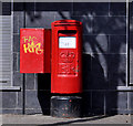
Pillar box, Belfast
EIIR pillar box at York Road, close to Grove Place.
Image: © Albert Bridge
Taken: 27 Apr 2011
0.17 miles
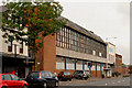
10
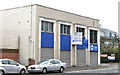
Nos 41-45 York Road, Belfast
A vacant office building at the corner of York Road and North Derby Street. The agent’s board advertises it “For sale/to let with development potential (STPP)”. STPP means “subject to planning permission”. This photograph appears as a matter of record only. I have no connection with any of the parties involved in the sale.
Image: © Albert Bridge
Taken: 5 May 2013
0.18 miles