IMAGES TAKEN NEAR TO
Alexandra Park Avenue, BELFAST, BT15 3ER
Introduction
This page details the photographs taken nearby to Alexandra Park Avenue, BT15 3ER by members of the Geograph project.
The Geograph project started in 2005 with the aim of publishing, organising and preserving representative images for every square kilometre of Great Britain, Ireland and the Isle of Man.

There are currently over 7.5m images from over14,400 individuals and you can help contribute to the project by visiting https://www.geograph.org.uk
Image Map
Images are licensed for reuse under creativecommons.org/licenses/by-sa/2.0
Notes
- Clicking on the map will re-center to the selected point.
- The higher the marker number, the further away the image location is from the centre of the postcode.
Image Listing (53 Images Found)
Images are licensed for reuse under creativecommons.org/licenses/by-sa/2.0
Image
Details
Distance
1
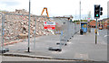
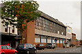
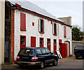
The remains of the Grove Baths, Belfast (2013-1)
See Image (August 2011). The demolition of this building, which seems to have been mostly reinforced concrete, is almost complete. This view is from Grove Place. Continue to Image
Image: © Albert Bridge
Taken: 5 May 2013
0.03 miles
2
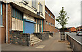
Former Grove Baths, Belfast (2)
The (closed) entrance, from York Road, to the former Grove Baths Image Demolition started on 8 February 2013. Image and Image show two views in May 2013.
Image: © Albert Bridge
Taken: 3 Aug 2011
0.04 miles
3
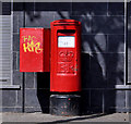
Pillar box, Belfast
EIIR pillar box at York Road, close to Grove Place.
Image: © Albert Bridge
Taken: 27 Apr 2011
0.04 miles
4
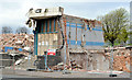
The remains of the Grove Baths, Belfast (2013-2)
See Image One small but recognisable part is still standing.
Image: © Albert Bridge
Taken: 5 May 2013
0.05 miles
5
Former Grove Baths, Belfast
My knowledge of north Belfast is extremely limited so no potted history. I can, however, say that the name “Grove” seems to come from The Grove and the Grove Lodge, two Victorian properties in the immediate area. Demolished on 8 February 2013. See also Image
Image: © Albert Bridge
Taken: 15 Oct 2010
0.05 miles
6
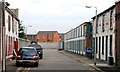
Jennymount Street, Belfast (1)
A street of urban cottages, off North Derby Street, probably associated with the original part of Jennymount Mill Image Not mentioned in the architectural guides and not on the “At Risk” register (but perhaps it should be). Some properties are in commercial use. Others are just fronts.
Image: © Albert Bridge
Taken: 15 Oct 2010
0.06 miles
7
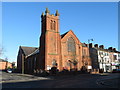
Alexandra Presbyterian Church, York Road, Belfast
Image: © Gareth James
Taken: 5 Apr 2018
0.07 miles
8
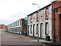
Jennymount Street, Belfast (3)
See Image Part of the eastern side of the street. Not on the “At Risk” register (but perhaps it should be).
Image: © Albert Bridge
Taken: 15 Oct 2010
0.07 miles
9
Jennymount Street, Belfast (2)
See Image Part of the western side of the street. Not on the “At Risk” register (but perhaps it should be).
Image: © Albert Bridge
Taken: 15 Oct 2010
0.07 miles
10
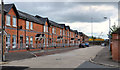
Ivan Street, Belfast
A late-19th century street, off York Road, recently redeveloped by a housing association. The M2 Image is behind the wall (background).
Image: © Albert Bridge
Taken: 3 Aug 2011
0.07 miles