
IMAGES TAKEN NEAR TO
North Queen Street, BELFAST, BT15 3DG
Introduction
This page details the photographs taken nearby to North Queen Street, BT15 3DG by members of the Geograph project.
The Geograph project started in 2005 with the aim of publishing, organising and preserving representative images for every square kilometre of Great Britain, Ireland and the Isle of Man.

There are currently over 7.5m images from over14,400 individuals and you can help contribute to the project by visiting https://www.geograph.org.uk
Image Map
Images are licensed for reuse under creativecommons.org/licenses/by-sa/2.0
Notes
- Clicking on the map will re-center to the selected point.
- The higher the marker number, the further away the image location is from the centre of the postcode.
Image Listing (62 Images Found)
Images are licensed for reuse under creativecommons.org/licenses/by-sa/2.0
Image
Details
Distance
1
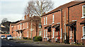
Parkmount Street, Belfast - February 2016(2)
See Image Replacement social housing, on the northern side of Parkmount Street, to the west of North Queen Street.
Image: © Albert Bridge
Taken: 24 Feb 2016
0.05 miles
2
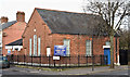
Belfast City Mission (Mountcollyer Hall), Belfast (February 2016)
Belfast City Mission http://www.belfastcitymission.com/, Mountcollyer Hall, at the corner of Mountcollyer Avenue (left) and North Queen Street. It seems to be of relatively-recent construction – possibly after 1960.
Image: © Albert Bridge
Taken: 24 Feb 2016
0.06 miles
3
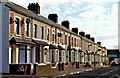
Parkmount Street, Belfast - February 2016(1)
The northern side of Parkmount Street, looking from North Queen Street to York Road. The 1890 street directory shows a street but no houses. The 1901 edition has it fully developed. This end still retains the original terrace houses. Image shows the western side of the street.
Image: © Albert Bridge
Taken: 24 Feb 2016
0.07 miles
4
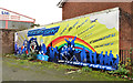
Tiger's Bay mural, Belfast
Self-explanatory mural at the corner of North Queen Street and the Limestone Road Image Tiger’s Bay is an area of inner-city north Belfast, between Brougham Street Image, North Queen Street and the Limestone and York Roads, which experienced considerable upheaval during the Troubles.
Image: © Albert Bridge
Taken: 21 Nov 2011
0.09 miles
5
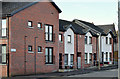
Lilliput Street, Belfast (February 2016)
Modern social housing in Lilliput Street, now a short street on the western side of North Queen Street. The original (much longer) street was built before 1880 and might take its name from a Lilliput Cottage on the nearby Limestone Road Image
Image: © Albert Bridge
Taken: 24 Feb 2016
0.10 miles
7
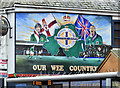
Northern Ireland football mural, York Road, Belfast (January 2017)
A Northern Ireland football mural on The Times bar at 24 York Street. The Times is a Bluenose establishment.
Image: © Albert Bridge
Taken: 22 Jan 2017
0.11 miles
8
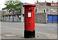
Pillar box, Belfast
EIIR pillar box, at York Road, opposite Milewater Street.
Image: © Albert Bridge
Taken: 3 Aug 2011
0.11 miles
9
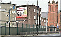
Former York Road police station, Belfast (January 2017)
The former York Road police station, at the corner of Seaview Street – a candidate for replacement by social housing.
Image: © Albert Bridge
Taken: 22 Jan 2017
0.12 miles
10
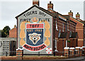
Tiger's Bay First Flute Band mural, Belfast (February 2016)
See Image (November 2011). A Tiger’s Bay First Flute Band mural at Hogarth Street/Mervue Street. This photograph appears as a matter of neutral record only. It should not be interpreted as making any political, sectarian or musical comment. See also Image and Image
Image: © Albert Bridge
Taken: 24 Feb 2016
0.13 miles