IMAGES TAKEN NEAR TO
Carlisle Terrace, BELFAST, BT15 2PR
Introduction
This page details the photographs taken nearby to Carlisle Terrace, BT15 2PR by members of the Geograph project.
The Geograph project started in 2005 with the aim of publishing, organising and preserving representative images for every square kilometre of Great Britain, Ireland and the Isle of Man.

There are currently over 7.5m images from over14,400 individuals and you can help contribute to the project by visiting https://www.geograph.org.uk
Image Map
Images are licensed for reuse under creativecommons.org/licenses/by-sa/2.0
Notes
- Clicking on the map will re-center to the selected point.
- The higher the marker number, the further away the image location is from the centre of the postcode.
Image Listing (143 Images Found)
Images are licensed for reuse under creativecommons.org/licenses/by-sa/2.0
Image
Details
Distance
1
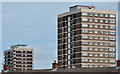
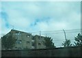
Artillery flats, Belfast (2013-2)
See Image Two of the blocks, at North Queen Street, rising above the roofs and chimneys at Gt George’s Street
Image: © Albert Bridge
Taken: 31 Jul 2013
0.04 miles
2
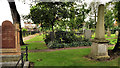
Clifton Street graveyard, Belfast (1)
Part of the graveyard beside Henry Place (hidden left).
Image: © Albert Bridge
Taken: 13 Sep 2011
0.06 miles
3
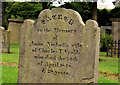
Clifton Street graveyard, Belfast (3)
A well-preserved headstone marking the grave of Anne Nicholls (wife of Charles T Crabb) who died in 1848.
Image: © Albert Bridge
Taken: 13 Sep 2011
0.06 miles
4
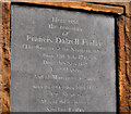
Clifton Street graveyard, Belfast (2)
Headstone marking the graves of Francis Dalzell Finlay (founder of the “Northern Whig” newspaper) Image - http://en.wikipedia.org/wiki/Whig_(British_political_party) and his family.
Image: © Albert Bridge
Taken: 13 Sep 2011
0.06 miles
5
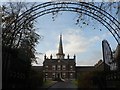
Belfast: Clifton House
Built in the 1770s, Clifton House was a home for the poor and needy.
Image: © Chris Downer
Taken: 10 Nov 2007
0.07 miles
6
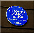
Sir Joseph Larmor plaque, Belfast
A plaque, at 24 Antrim Road, commemorating Sir Joseph Larmor http://www.ulsterhistory.co.uk/larmor.htm.
Image: © Albert Bridge
Taken: 28 Mar 2010
0.07 miles
7
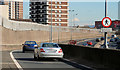
Apartments in Carlisle Road, Belfast
These stand adjacent to the Artillery Flats. The image is taken from the Westlink
a dual carriageway throughpass, designated the A12, and connecting the M1 to the M2 and M3 motorways
Image: © Eric Jones
Taken: 9 Aug 2011
0.07 miles
8
The Artillery Flats from Clifton Street
The Nationalist Artillery Flats are here viewed across the interface from the Loyalist Clifton Street. The silver car has just started to cross the Clifton Street bridge over the Westlink road.
Image: © Eric Jones
Taken: 10 Jul 2015
0.07 miles
9

Assembly election poster, Antrim Road, Belfast - April 2016(2)
Antrim Road. Gemma Weir (Workers Party).
Image: © Albert Bridge
Taken: 20 Apr 2016
0.08 miles
10
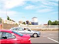
The Westlink, Belfast (14)
See Image The north and eastbound on-slip at Clifton Street with the Artillery Flats Image in the background.
Image: © Albert Bridge
Taken: 1 Mar 2010
0.09 miles