IMAGES TAKEN NEAR TO
Maralin Place, BELFAST, BT15 2HH
Introduction
This page details the photographs taken nearby to Maralin Place, BT15 2HH by members of the Geograph project.
The Geograph project started in 2005 with the aim of publishing, organising and preserving representative images for every square kilometre of Great Britain, Ireland and the Isle of Man.

There are currently over 7.5m images from over14,400 individuals and you can help contribute to the project by visiting https://www.geograph.org.uk
Image Map
Images are licensed for reuse under creativecommons.org/licenses/by-sa/2.0
Notes
- Clicking on the map will re-center to the selected point.
- The higher the marker number, the further away the image location is from the centre of the postcode.
Image Listing (66 Images Found)
Images are licensed for reuse under creativecommons.org/licenses/by-sa/2.0
Image
Details
Distance
2
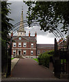
Clifton House
Entrance gates to Clifton House
One of Belfast’s most historic buildings, Clifton House was completed in 1774 by the Belfast Charitable Society as a base for their work with the poor and needy. It is usually open for tours during the European Heritage Open Days in September each year and is well worth a visit. http://www.cliftonbelfast.org.uk/home.htm
Image: © Rossographer
Taken: 30 Jul 2007
0.04 miles
3
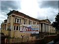
Crumlin Road Courthouse
Now derelict, the Crumlin Road Courthouse was designed by the architect Charles Lanyon and completed in 1850. It is situated across the road from the Crumlin Road Gaol and the two are linked by an underground passage.
Until closure in 1998 it was the scene of many high profile terrorist trials; Belfast Crown Court has now moved to Oxford Street.
The building is currently awaiting redevelopment, with rumours that it is to be turned into a 5-star hotel.
Image: © Rossographer
Taken: 8 Aug 2007
0.04 miles
4
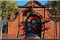
Former Friends Meeting House, Belfast
The former meeting house, in Frederick Street, was built in 1840. It is now the office of a charity. The Society of Friends still meets to the side and rear of the building.
Image: © Albert Bridge
Taken: 4 Oct 2007
0.04 miles
5
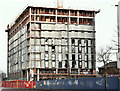
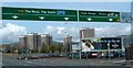
Nos 123-137 York Street, Belfast - January 2019(1)
The site from the corner of Frederick Street. Torn insulation wrapping has the appearance of broken glass.
Image: © Albert Bridge
Taken: 13 Jan 2019
0.04 miles
6
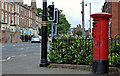
Pillar box, Belfast
GVIR pillar box, on the Antrim Road just past Dawson Street.
Image: © Albert Bridge
Taken: 23 May 2011
0.06 miles
7
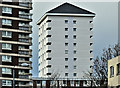
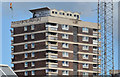
Renovated block, Artillery Flats, Belfast (January 2017)
See Image A second renovated block – at the north western end of the site.
Image: © Albert Bridge
Taken: 3 Jan 2017
0.11 miles
8
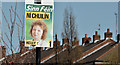
Assembly election poster, Antrim Road, Belfast - April 2016(1)
Antrim Road. Carál Ní Chuilín and Gerry Kelly (Sinn Féin).
Image: © Albert Bridge
Taken: 20 Apr 2016
0.11 miles
9

Assembly election poster, Antrim Road, Belfast - April 2016(2)
Antrim Road. Gemma Weir (Workers Party).
Image: © Albert Bridge
Taken: 20 Apr 2016
0.13 miles
10
Artillery Flats, Belfast (3 in 2013)
Part of one of the blocks seen, across the rooftops, from Frederick Street.
Image: © Albert Bridge
Taken: 6 Sep 2013
0.14 miles