IMAGES TAKEN NEAR TO
Spamount Street, BELFAST, BT15 2FB
Introduction
This page details the photographs taken nearby to Spamount Street, BT15 2FB by members of the Geograph project.
The Geograph project started in 2005 with the aim of publishing, organising and preserving representative images for every square kilometre of Great Britain, Ireland and the Isle of Man.

There are currently over 7.5m images from over14,400 individuals and you can help contribute to the project by visiting https://www.geograph.org.uk
Image Map
Images are licensed for reuse under creativecommons.org/licenses/by-sa/2.0
Notes
- Clicking on the map will re-center to the selected point.
- The higher the marker number, the further away the image location is from the centre of the postcode.
Image Listing (64 Images Found)
Images are licensed for reuse under creativecommons.org/licenses/by-sa/2.0
Image
Details
Distance
1

Victorian pillar box, Belfast
A VR pillar box, cast by A Handyside & Co Ltd http://www.geograph.org.uk/search.php?i=24683182, near the North Queen Street end of Duncairn Gardens Image
Image: © Albert Bridge
Taken: 8 Sep 2011
0.07 miles
2
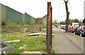
Vacant site, Duncairn Gardens, Belfast
A vacant site, on the south western side of Duncairn Gardens, close to the original line of Upper Meadow Street.
Image: © Albert Bridge
Taken: 10 Apr 2014
0.07 miles
3
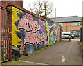
Graffiti, Belfast (April 2014)
“Still star struck after 2 years” on a gated entry leading from Hillman Court to Duncairn Gardens.
Image: © Albert Bridge
Taken: 10 Apr 2014
0.07 miles
4
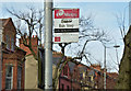
Bus stop, Duncairn Gardens, Belfast (February 2016)
A bus stop, named “North City Business Centre” on the north eastern side of Duncairn Gardens. Served by the inward Metro 1D - Mossley West station Image to Donegall Place via the Antrim Road.
The business centre was a successful attempt to regenerate an area badly affected by The Troubles.
Image: © Albert Bridge
Taken: 24 Feb 2016
0.08 miles
5
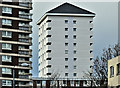
Renovated block, Artillery Flats, Belfast (January 2017)
See Image A second renovated block – at the north western end of the site.
Image: © Albert Bridge
Taken: 3 Jan 2017
0.09 miles
6
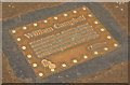
William Campbell ("Titanic") plaque, Belfast
See Image (Templemore Avenue). A similar plaque, at North Queen Street, opposite Spamount Street. It reads “William Campbell, an Apprentice Joiner at Harland & Wolff, lived in Earl Street, a site now occupied by the shopping centre. He was a member of the company’s Guarantee Group for RMS Titanic and lost his life on the voyage”.
Image: © Albert Bridge
Taken: 10 Apr 2014
0.10 miles
7
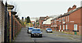
Upper Canning Street, Belfast (February 2016)
See Image (August 2010). Upper Canning Street was the continuation of Canning Street across North Queen Street. Built after 1880 and now redeveloped with social housing. This view is from the eastern end with part of the North City Business Centre, Duncairn Gardens on the left.
Image: © Albert Bridge
Taken: 24 Feb 2016
0.12 miles
8
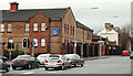
Brougham Street, Belfast (2)
See Image The upper part of Brougham Street with North Queen Street running across and Duncairn Gardens straight ahead.
Image: © Albert Bridge
Taken: 5 Feb 2010
0.12 miles
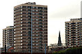
9
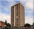
Artillery Flats, Belfast (2)
Image: © Albert Bridge
Taken: 8 Sep 2011
0.13 miles
10
Artillery flats, Belfast
The view from Brougham Street Image
Image: © Albert Bridge
Taken: 5 Feb 2010
0.13 miles