IMAGES TAKEN NEAR TO
Queens Parade, BELFAST, BT15 2ER
Introduction
This page details the photographs taken nearby to Queens Parade, BT15 2ER by members of the Geograph project.
The Geograph project started in 2005 with the aim of publishing, organising and preserving representative images for every square kilometre of Great Britain, Ireland and the Isle of Man.

There are currently over 7.5m images from over14,400 individuals and you can help contribute to the project by visiting https://www.geograph.org.uk
Image Map
Images are licensed for reuse under creativecommons.org/licenses/by-sa/2.0
Notes
- Clicking on the map will re-center to the selected point.
- The higher the marker number, the further away the image location is from the centre of the postcode.
Image Listing (115 Images Found)
Images are licensed for reuse under creativecommons.org/licenses/by-sa/2.0
Image
Details
Distance
1
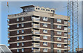
Artillery Flats, Belfast (3 in 2013)
Part of one of the blocks seen, across the rooftops, from Frederick Street.
Image: © Albert Bridge
Taken: 6 Sep 2013
0.01 miles
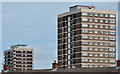
2
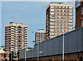
Artillery flats, Belfast (2013-1)
See Image Three of the blocks, at North Queen Street, seen from the York Street end of Henry Street. Part of the former “Gallahers” factory Image and Image is on the right. Continue to Image
Image: © Albert Bridge
Taken: 31 Jul 2013
0.02 miles
3
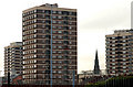
Artillery flats, Belfast
The view from Brougham Street Image
Image: © Albert Bridge
Taken: 5 Feb 2010
0.02 miles
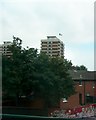
4
The Artillery Flats from Clifton House
The Artillery Flats, so called because they were built on the site of a former artillery barracks, are in the heart of the strongly republican New Lodge district.
https://commons.wikimedia.org/wiki/File:Artillery_Flats,_Belfast,_July_2010_(02).JPG
Image: © Eric Jones
Taken: 10 Jul 2015
0.04 miles
5
Artillery flats, Belfast (2013-2)
See Image Two of the blocks, at North Queen Street, rising above the roofs and chimneys at Gt George’s Street
Image: © Albert Bridge
Taken: 31 Jul 2013
0.07 miles
6
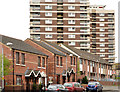
Victoria Parade, Belfast
Victoria Parade/Paráid Victoria – a street on the western side of North Queen Street dominated by the tower blocks of the Artillery Flats http://www.geograph.org.uk/snippet/9661.
Image: © Albert Bridge
Taken: 10 Apr 2014
0.08 miles
8
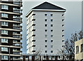
Renovated block, Artillery Flats, Belfast (January 2017)
See Image A second renovated block – at the north western end of the site.
Image: © Albert Bridge
Taken: 3 Jan 2017
0.09 miles
9
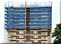
Artillery Flats, Belfast (June 2014)
One of the blocks enclosed by scaffolding and mesh. Image shows the new roof. Image shows the block after completion of the work.
Image: © Albert Bridge
Taken: 26 Jun 2014
0.10 miles
10
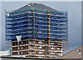
Artillery Flats, Belfast (July 2014)
Image: © Albert Bridge
Taken: 27 Jul 2014
0.10 miles