IMAGES TAKEN NEAR TO
Canning Place, BELFAST, BT15 1NE
Introduction
This page details the photographs taken nearby to Canning Place, BT15 1NE by members of the Geograph project.
The Geograph project started in 2005 with the aim of publishing, organising and preserving representative images for every square kilometre of Great Britain, Ireland and the Isle of Man.

There are currently over 7.5m images from over14,400 individuals and you can help contribute to the project by visiting https://www.geograph.org.uk
Image Map
Images are licensed for reuse under creativecommons.org/licenses/by-sa/2.0
Notes
- Clicking on the map will re-center to the selected point.
- The higher the marker number, the further away the image location is from the centre of the postcode.
Image Listing (161 Images Found)
Images are licensed for reuse under creativecommons.org/licenses/by-sa/2.0
Image
Details
Distance
1
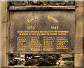
St Paul's war memorial, Belfast
WWII memorial on the southern side of the bell tower of St Paul’s church Image, York Street.
Image: © Albert Bridge
Taken: 21 Nov 2011
0.02 miles
2
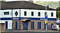
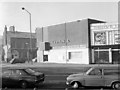
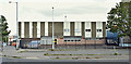
The Ulster Bank, York Street, Belfast (September 2017)
See Image (July 2013) and Image (February 1976). Still open after two rounds of branch closures and major local redevelopment.
Image: © Albert Bridge
Taken: 2 Sep 2017
0.03 miles
3
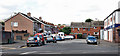
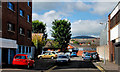
Midland Terrace, Belfast
Midland Terrace is what was once called Canning Street. The “Midland” comes from the LMS Railway which, until the nationalisation of railways under the Ulster Transport Authority, operated from nearby York Road station. Some of the houses date from the 1970’s and were built by a private developer in a Government-promoted attempt to encourage rejuvenation in an area affected by the troubles. The scheme was not completed in the form envisaged.
Image: © Albert Bridge
Taken: 17 Aug 2010
0.03 miles
4
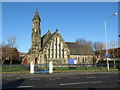
St Paul and St Barnabas church, York Road, Belfast
Image: © Gareth James
Taken: 5 Apr 2018
0.03 miles
5
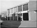
Ulster Bank - York Road new premises
Seen just before opening, this replaced the temporary premises just round the corner in Canning Street. See Image
A recent photograph of the even newer premises can be found: Image] .
Image: © The Carlisle Kid
Taken: Unknown
0.05 miles
6
Ulster Bank - York Road temporary premises
Temporary premises of Ulster Bank at the corner of Canning Street and York Road. Intended as a short-term replacement for the original bank, demolished to make way for the cross-Lagan rail & road link, this temporary building served for at least 10 years before being replaced in the mid-1970s by a new building off camera to the right. By the end, the temporary building had no roof (vandalism) and rain water ran down the walls, making carpets somewhat slippery. See Image
Image: © The Carlisle Kid
Taken: Unknown
0.05 miles
7
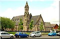
St Paul's (CoI) church, Belfast
At the York Road end of York Street, St Paul’s Church of Ireland dates from 1851. It came from Lanyon’s practice but some suggest that the man at the drawing board was WH Lynn. The surrounding area has been redeveloped resulting in a much-reduced population. Image shows the WWII memorial.
Image: © Albert Bridge
Taken: 23 Jul 2009
0.05 miles
8
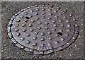
Millfield Foundry manhole cover, Belfast (3)
A Millfield Foundry http://www.geograph.org.uk/search.php?i=23662723 manhole cover, at the York Road end of Hanna Street Image
Image: © Albert Bridge
Taken: 3 Aug 2011
0.06 miles
9
Nos 2-6 Whitla Street, Belfast (September 2017)
The former “Plumb Center” (the business has moved to other premises) is now vacant. It and the Midland Building Image (out of picture to the right) are destined to become part of the NIR workshops, after redevelopment.
Image: © Albert Bridge
Taken: 2 Sep 2017
0.06 miles
10
Hanna Street, Belfast
Now a short cul-de-sac off York Street, Hanna Street was built circa 1870 and originally had almost 70 houses.
Image: © Albert Bridge
Taken: 17 Aug 2010
0.06 miles