IMAGES TAKEN NEAR TO
Whitla Street, BELFAST, BT15 1JP
Introduction
This page details the photographs taken nearby to Whitla Street, BT15 1JP by members of the Geograph project.
The Geograph project started in 2005 with the aim of publishing, organising and preserving representative images for every square kilometre of Great Britain, Ireland and the Isle of Man.

There are currently over 7.5m images from over14,400 individuals and you can help contribute to the project by visiting https://www.geograph.org.uk
Image Map
Images are licensed for reuse under creativecommons.org/licenses/by-sa/2.0
Notes
- Clicking on the map will re-center to the selected point.
- The higher the marker number, the further away the image location is from the centre of the postcode.
Image Listing (200 Images Found)
Images are licensed for reuse under creativecommons.org/licenses/by-sa/2.0
Image
Details
Distance
1
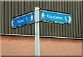
Pedestrian sign, Belfast
A direction sign, for pedestrians, close to the site of the entrance of the old York Road station Image The station no longer exists.
Image: © Albert Bridge
Taken: 23 Jul 2009
0.01 miles
2
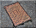
Fire hydrant cover, Belfast
A Dudley Dauntless http://www.thomasdudley.co.uk/ cover, in York Street, near the site of the old York Road station.
Image: © Albert Bridge
Taken: 17 Aug 2010
0.02 miles
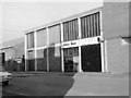
3
Ulster Bank - York Road new premises
Seen just before opening, this replaced the temporary premises just round the corner in Canning Street. See Image
A recent photograph of the even newer premises can be found: Image] .
Image: © The Carlisle Kid
Taken: Unknown
0.02 miles
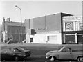
4
Ulster Bank - York Road temporary premises
Temporary premises of Ulster Bank at the corner of Canning Street and York Road. Intended as a short-term replacement for the original bank, demolished to make way for the cross-Lagan rail & road link, this temporary building served for at least 10 years before being replaced in the mid-1970s by a new building off camera to the right. By the end, the temporary building had no roof (vandalism) and rain water ran down the walls, making carpets somewhat slippery. See Image
Image: © The Carlisle Kid
Taken: Unknown
0.02 miles
5
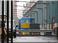
York Road Depot, Belfast
NIR locomotive No. 8113 is found around the back of York Road Depot, Belfast.
Image: © Gareth James
Taken: 4 Oct 2019
0.02 miles
6
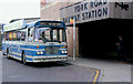
Rail-Link bus, Belfast (2)
See Image The Rail-Link bus was the successor to the Citylink service. It connected York Road and Central stations but using a shorter route. This one is a Bristol RELL at York Road.
Image: © Albert Bridge
Taken: 30 May 1987
0.02 miles
7
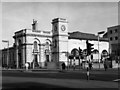
York Road railway station
Built by the Belfast & Ballymena Railway to a design by Sir Charles Lanyon, York Road station opened in 1848. Very badly damaged in the 1941 Blitz, it suffered further bomb damage in the 1970s. Closed in 1975, the remaining buildings were later demolished. For an interior view, see Image
Image: © The Carlisle Kid
Taken: Unknown
0.02 miles
8
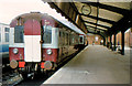
MPD railcars, Belfast
A two-cat MPD set (64 and 63) at Belfast York Road with the 15.50 to Antrim. This was a short-lived local service, via Bleach Green, which attracted few passengers.
Image: © Albert Bridge
Taken: 23 Aug 1980
0.02 miles
9
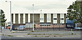
Nos 2-6 Whitla Street, Belfast (September 2017)
The former “Plumb Center” (the business has moved to other premises) is now vacant. It and the Midland Building Image (out of picture to the right) are destined to become part of the NIR workshops, after redevelopment.
Image: © Albert Bridge
Taken: 2 Sep 2017
0.02 miles
10
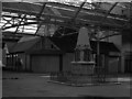
Interior York Road railway station
For information on the history of this station, see Image
View shows war memorial and station bar. Offices within the station were in a Swiss Chalet style devised by the railway company's engineer, Berkley Deane Wise. Those that survived the 1941 Blitz were destroyed by bombs in the 1970s, although one kiosk is preserved at the Cultra Folk & Transport Museum.
Image: © The Carlisle Kid
Taken: Unknown
0.03 miles