IMAGES TAKEN NEAR TO
North Queen Street, BELFAST, BT15 1HS
Introduction
This page details the photographs taken nearby to North Queen Street, BT15 1HS by members of the Geograph project.
The Geograph project started in 2005 with the aim of publishing, organising and preserving representative images for every square kilometre of Great Britain, Ireland and the Isle of Man.

There are currently over 7.5m images from over14,400 individuals and you can help contribute to the project by visiting https://www.geograph.org.uk
Image Map
Images are licensed for reuse under creativecommons.org/licenses/by-sa/2.0
Notes
- Clicking on the map will re-center to the selected point.
- The higher the marker number, the further away the image location is from the centre of the postcode.
Image Listing (111 Images Found)
Images are licensed for reuse under creativecommons.org/licenses/by-sa/2.0
Image
Details
Distance
1
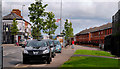
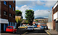
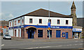
North Queen Street, Belfast (1)
North Queen Street is quite a long inner-city street running from the top of Donegall Street, across the Limestone Road, to the Shore Road at Skegoneil. To the best of my knowledge it was once part of the main road to Carrickfergus. The view is from near Brougham Street towards the Shore Road. This general area is what the media calls an “interface area”. Continue to Image
Image: © Albert Bridge
Taken: 25 Aug 2010
0.02 miles
2
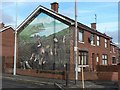
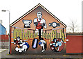
Belfast: an apolitical mural
While many of the murals around Belfast remind us of the city's political troubles of the 20th century, this one depicts the 'great hunger', as written in English under the right-hand part of the gable. The left-hand part says the same in Gaelic.
Image: © Chris Downer
Taken: 11 Nov 2007
0.04 miles
3
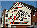
Tiger's Bay mural, Cultra Street, Belfast (February 2016)
See Image (November 2011). A self-explanatory mural at the North Queen Street end of Cultra Street.
Image: © Albert Bridge
Taken: 24 Feb 2016
0.06 miles
4
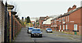
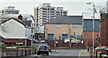
Upper Canning Street, Belfast (February 2016)
See Image (August 2010). Upper Canning Street was the continuation of Canning Street across North Queen Street. Built after 1880 and now redeveloped with social housing. This view is from the eastern end with part of the North City Business Centre, Duncairn Gardens on the left.
Image: © Albert Bridge
Taken: 24 Feb 2016
0.06 miles
5
Boxing mural, Belfast
Midland Boxing Club http://en.wikipedia.org/wiki/Carl_Frampton mural, tucked away on a gable wall at Cultra Street, off York Road. The name “Midland” comes from the Midland Railway (Northern Counties Committee) which once operated from the nearby York Road station Image and Image
Image: © Albert Bridge
Taken: 21 Nov 2011
0.08 miles
6
Glenrosa Street, Belfast (February 2016)
The original Glenrosa Street, built before 1890, was much longer and ran from Mervue Street through to Duncairn Gardens. This is the re-built version seen from Mervue Street.
Image: © Albert Bridge
Taken: 24 Feb 2016
0.09 miles
7
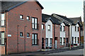
Lilliput Street, Belfast (February 2016)
Modern social housing in Lilliput Street, now a short street on the western side of North Queen Street. The original (much longer) street was built before 1880 and might take its name from a Lilliput Cottage on the nearby Limestone Road Image
Image: © Albert Bridge
Taken: 24 Feb 2016
0.09 miles
8
Hanna Street, Belfast
Now a short cul-de-sac off York Street, Hanna Street was built circa 1870 and originally had almost 70 houses.
Image: © Albert Bridge
Taken: 17 Aug 2010
0.09 miles
9
The Ulster Bank, York Road, Belfast
See Image The York Road branch at the corner of Canning Street (left) and York Road. See also Image and Image – both February 1976. This church Image is on the right.
Image: © Albert Bridge
Taken: 31 Jul 2013
0.09 miles
10
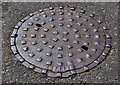
Millfield Foundry manhole cover, Belfast (3)
A Millfield Foundry http://www.geograph.org.uk/search.php?i=23662723 manhole cover, at the York Road end of Hanna Street Image
Image: © Albert Bridge
Taken: 3 Aug 2011
0.10 miles