IMAGES TAKEN NEAR TO
Church Lane, BELFAST, BT1 4QN
Introduction
This page details the photographs taken nearby to Church Lane, BT1 4QN by members of the Geograph project.
The Geograph project started in 2005 with the aim of publishing, organising and preserving representative images for every square kilometre of Great Britain, Ireland and the Isle of Man.

There are currently over 7.5m images from over14,400 individuals and you can help contribute to the project by visiting https://www.geograph.org.uk
Image Map
Images are licensed for reuse under creativecommons.org/licenses/by-sa/2.0
Notes
- Clicking on the map will re-center to the selected point.
- The higher the marker number, the further away the image location is from the centre of the postcode.
Image Listing (3667 Images Found)
Images are licensed for reuse under creativecommons.org/licenses/by-sa/2.0
Image
Details
Distance
1
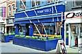
"Downtools", Church Lane, Belfast (September 2019)
Recently-opened café at 24-26 Church Lane. It occupies the former McMaster’s tool shop (on the right in Image (December 2008)).
“Down Tools is named in honour of W.M. McMaster’s toolshop and saw repair workshop. For over 120 years, it repaired the broken and brought useful things to busy people. We want to carry on the tradition, DIYing our own sandwiches, slow roasting pork and beef each day and finishing the job with custom made dressings, soups, salads and cakes” - official website. I have no connection with the business and cannot enter into correspondence.
Image: © Albert Bridge
Taken: 17 Sep 2019
0.01 miles
2
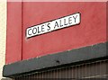
Cole's Alley, Belfast (4)
See Image Proof that, unlike hippogryphs, Cole’s Alley does exist.
Image: © Albert Bridge
Taken: 9 Aug 2009
0.01 miles
3

Fire appliance, Belfast
In Church Lane, attending to what turned out to be a false alarm.
Image: © Albert Bridge
Taken: 25 Sep 2008
0.01 miles
4
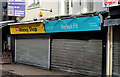
"To let" shops, Belfast (24)
A former branch of “The Money Shop” at 16 Church Lane.
Image: © Albert Bridge
Taken: 4 Nov 2012
0.01 miles
5
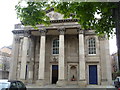
St George's Church [1]
The church dates from the early nineteenth century and is constructed on a site of great antiquity that stood at the heart of the first settlement in the area. It is the earliest episcopal church still standing in the city of Belfast. Listed, grade A, there many details and much history at: http://www.doeni.gov.uk/niea/built/buildview?id=8669
Image: © Michael Dibb
Taken: 8 Jun 2015
0.01 miles
6
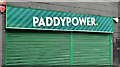
Paddy Power sign, Belfast (March 2017)
There was a time when the NI betting business was mainly Eastwoods and L Stanley both of whom were acquired by national concerns. Paddy Power https://en.wikipedia.org/wiki/Paddy_Power , based in the Republic, acquired McGranaghan Racing nine years ago. The main local bookmaker is now A McLean Image
This sign is at 36-38 Church Lane.
Image: © Albert Bridge
Taken: 19 Mar 2017
0.02 miles
7
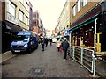
Church Lane, Belfast
Heading NNW from Ann Street
Image: © Kenneth Allen
Taken: 26 Nov 2018
0.02 miles
8
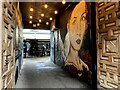
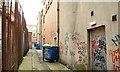
Mural, Belfast
Pictured off Church Lane
Image: © Kenneth Allen
Taken: 1 Dec 2022
0.02 miles
9
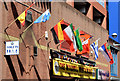
World Cup flags, Belfast (June 2014)
World Cup flags on the Church Lane side of the Hi-Park.
Image: © Albert Bridge
Taken: 22 Jun 2014
0.02 miles
10
Cole's Alley, Belfast (2)
Image: © Albert Bridge
Taken: 9 Aug 2009
0.02 miles