IMAGES TAKEN NEAR TO
Upper Church Lane, BELFAST, BT1 4QL
Introduction
This page details the photographs taken nearby to Upper Church Lane, BT1 4QL by members of the Geograph project.
The Geograph project started in 2005 with the aim of publishing, organising and preserving representative images for every square kilometre of Great Britain, Ireland and the Isle of Man.

There are currently over 7.5m images from over14,400 individuals and you can help contribute to the project by visiting https://www.geograph.org.uk
Image Map
Images are licensed for reuse under creativecommons.org/licenses/by-sa/2.0
Notes
- Clicking on the map will re-center to the selected point.
- The higher the marker number, the further away the image location is from the centre of the postcode.
Image Listing (3477 Images Found)
Images are licensed for reuse under creativecommons.org/licenses/by-sa/2.0
Image
Details
Distance
1
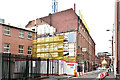
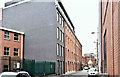
Nos 91-97 Victoria Street, Belfast - August 2017(1)
Another site where progress is hidden behind plastic mesh. Zooming in, on the original, shows that the building is now a shell retaining the original façade.
Image: © Albert Bridge
Taken: 27 Aug 2017
0.00 miles
2
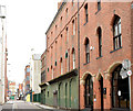
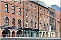
Nos 91-97 Victoria Street, Belfast - April 2015(4)
The Upper Church Lane side looking towards Ann Street. The solicitors’ office (right) is not part of the proposed scheme.
Image: © Albert Bridge
Taken: 19 Apr 2015
0.01 miles
3
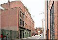
Nos 91-97 Victoria Street, Belfast - April 2015(5)
The Upper Church Lane side seen from the Ann Street end. Nos 91/93 (proposed for demolition) is the flat-roofed building on the left. Image shows a similar view after redevelopment.
Image: © Albert Bridge
Taken: 19 Apr 2015
0.01 miles
4
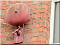
Nos 91-97 Victoria Street, Belfast - April 2015(6)
One of two fire alarm bells on the Upper Church Lane side of 95/97 – a listed building.
Image: © Albert Bridge
Taken: 19 Apr 2015
0.01 miles
5
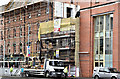
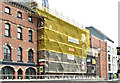
Nos 91-97 Victoria Street, Belfast - March 2017(1)
Erection of scaffolding along the Victoria Street frontage. Demolition of nos 91/93 is underway (second right).
Image: © Albert Bridge
Taken: 19 Mar 2017
0.01 miles
6
Nos 91-97 Victoria Street, Belfast - April 2015(1)
The Victoria Street side seen from the south east. This ramp Image is in the foreground. The solicitors’ office (left) is not part of the proposed scheme.
Image: © Albert Bridge
Taken: 19 Apr 2015
0.01 miles
7
Nos 91-97 Victoria Street, Belfast - April 2015(2)
The Victoria Street side seen from the north east. This ramp Image is on the left. The dull red building (second right) is 91/93 – proposed for demolition.
Image: © Albert Bridge
Taken: 19 Apr 2015
0.01 miles
8
Nos 91-97 Victoria Street, Belfast - August 2017(2)
Upper Church Lane – the back view. Nothing to see here.
Image: © Albert Bridge
Taken: 27 Aug 2017
0.01 miles
9
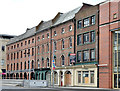
Nos 91-97 Victoria Street, Belfast (March 2019)
The Upper Church Lane side, looking towards Victoria Square, of the completed development. Image shows a similar view before rebuilding.
Image: © Albert Bridge
Taken: 10 Mar 2019
0.01 miles
10
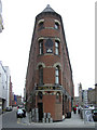
Bittles Bar, Belfast
It is located at Upper Church Lane
Image: © Kenneth Allen
Taken: 30 Mar 2009
0.01 miles