IMAGES TAKEN NEAR TO
May Street, BELFAST, BT1 4NA
Introduction
This page details the photographs taken nearby to May Street, BT1 4NA by members of the Geograph project.
The Geograph project started in 2005 with the aim of publishing, organising and preserving representative images for every square kilometre of Great Britain, Ireland and the Isle of Man.

There are currently over 7.5m images from over14,400 individuals and you can help contribute to the project by visiting https://www.geograph.org.uk
Image Map
Images are licensed for reuse under creativecommons.org/licenses/by-sa/2.0
Notes
- Clicking on the map will re-center to the selected point.
- The higher the marker number, the further away the image location is from the centre of the postcode.
Image Listing (2725 Images Found)
Images are licensed for reuse under creativecommons.org/licenses/by-sa/2.0
Image
Details
Distance
1
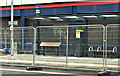
"Glider" halt, May Street, Belfast (August 2018)
Belfast Rapid Transit “Glider” halt, under construction, at May Street. The service is due to start next month. For the shape of things to come see https://www.youtube.com/watch?v=z6QPNibzmJQ
Image: © Albert Bridge
Taken: 12 Aug 2018
0.00 miles
2
![The Housing Centre, Belfast [part]](https://s1.geograph.org.uk/photos/73/69/736945_d863774a_120x120.jpg)
The Housing Centre, Belfast [part]
Part of the Northern Ireland Housing Executive headquarters 'The Housing Centre', Belfast. Although the address is given as 2 Adelaide Street, this part of the building fronts onto Alfred Street.
It was constructed in 1978 replacing Matier's linen warehouse.
Image: © Rossographer
Taken: 22 Mar 2008
0.01 miles
3
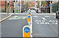
Two-way cycle lane, Alfred Street, Belfast (April 2016)
A new two-way cycle lane now open at Alfred Street. It connects with the one in Upper Arthur Street Image (background).
Image: © Albert Bridge
Taken: 24 Apr 2016
0.01 miles
4

Assembly election poster, May Street, Belfast (April 2016)
May Street/Alfred Street corner. Arlene Foster (Democratic Unionist Party).
Image: © Albert Bridge
Taken: 24 Apr 2016
0.01 miles
5
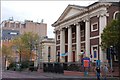
May Street Presbyterian church, Belfast
The May Street frontage. The smaller building to the immediate left was formerly a school. It dates from 1858/9.
Image: © Albert Bridge
Taken: 21 Oct 2007
0.01 miles
6
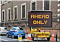
"Ahead only" road sign, Alfred Street, Belfast (April 2016)
A temporary sign, in place at Alfred Street following construction of the new cycle lane Image, reminding drivers that there is no right turn into May Street. For the record May Street has been one way (westwards) for at least 50 years.
Image: © Albert Bridge
Taken: 24 Apr 2016
0.01 miles
7
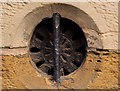
Cast-iron ventilator, Belfast
A cast-iron ventilator, at ground level, in the former Clarence Place Hall (1866), May Street. No maker’s name visible.
Image: © Albert Bridge
Taken: 22 Jan 2012
0.02 miles
8
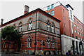
Belfast - City Centre - Attractive Red & Gray Brick Building along May Street
Location is along the north side of May Street between Donegall Square East and Upper Arthur Street. View is to the northwest from the SE corner of May Street & Alfred Street towards the south & east sides of the building.
Image: © Suzanne Mischyshyn
Taken: 23 Sep 2013
0.02 miles
9
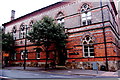
Belfast City Centre - Colourful Building at NW corner of May St & Upper Arthur St
View is from southwest corner of Alfred Street & May Street.
Image: © Joseph Mischyshyn
Taken: 23 Sep 2013
0.02 miles
10
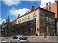
Clarence House, Belfast
Occupying 4-10 May Street, Belfast, this building now houses a 'property consultancy firm'. It was constructed 1865-67 to a design by Lanyon, Lynn and Lanyon. The rear of Belfast City Hall is visible to the left of picture and part of the 'Belfast Wheel' is just seen rising above. The unfortunate shadow across is the result of the seven storey 'The Housing Centre' (see Image) opposite.
Image: © Rossographer
Taken: 22 Mar 2008
0.02 miles