IMAGES TAKEN NEAR TO
Pattersons Place, BELFAST, BT1 4HW
Introduction
This page details the photographs taken nearby to Pattersons Place, BT1 4HW by members of the Geograph project.
The Geograph project started in 2005 with the aim of publishing, organising and preserving representative images for every square kilometre of Great Britain, Ireland and the Isle of Man.

There are currently over 7.5m images from over14,400 individuals and you can help contribute to the project by visiting https://www.geograph.org.uk
Image Map
Images are licensed for reuse under creativecommons.org/licenses/by-sa/2.0
Notes
- Clicking on the map will re-center to the selected point.
- The higher the marker number, the further away the image location is from the centre of the postcode.
Image Listing (3097 Images Found)
Images are licensed for reuse under creativecommons.org/licenses/by-sa/2.0
Image
Details
Distance
1
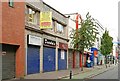
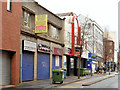
Nos 51-55 Upper Arthur Street, Belfast
Nos 51-53 and no 55 are proposed for demolition and replacement by two separate office developments. Continue to Image
Image: © Albert Bridge
Taken: 9 Aug 2009
0.01 miles
2

The Belfast Wheel
Normally you get three revolutions, but we were treated to five
Image: © Kenneth Allen
Taken: 30 Mar 2009
0.01 miles
3
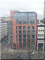
Bank of Ireland, Belfast
Viewed from the Belfast Wheel
Image: © Kenneth Allen
Taken: 30 Mar 2009
0.01 miles
4
Street art, Patterson's Place, Belfast (October 2017)
Image: © Albert Bridge
Taken: 14 Oct 2017
0.01 miles
5
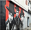
Street art, Patterson's Place, Belfast (April 2018)
Street art at the Upper Arthur Street end of Patterson's Place. It replaced this Image Image shows the replacement.
Image: © Albert Bridge
Taken: 1 Apr 2018
0.01 miles
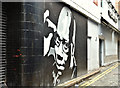
6
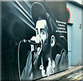
Street art, Patterson's Place, Belfast (December 2018)
Street art at the Upper Arthur Street end of Patterson's Place. It replaced this Image
Image: © Albert Bridge
Taken: 16 Dec 2018
0.01 miles
7
No 55 Upper Arthur Street, Belfast (March 2014)
See Image (August 2009). The property remains with a “for sale” sign. The agents describe it thus “Full planning consent has been obtained for a 7 storey office development. The proposed plans comprise of ground floor retail of c. 2,798 sq ft together with 6 storey`s of offices totalling c. 12,594 sq ft.”. This photograph appears as a matter of record only. I have no connection with any of the parties involved in the sale. Continue to Image
Image: © Albert Bridge
Taken: 9 Mar 2014
0.01 miles
8
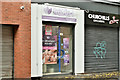
No 55 Upper Arthur Street, Belfast (October 2018)
See Image One of the units now offers Thai massage. I have no connection with the business and cannot enter into correspondence.
Image: © Albert Bridge
Taken: 21 Oct 2018
0.01 miles
9
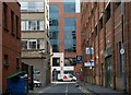
Arthur Lane, Belfast
Arthur Lane runs from Arthur Street to Montgomery Street (background). Nothing much in it except a multi-storey car park and the public toilets. On the other hand, it might be a suitable place for a bin-hoaker to pass the time seeking untold treasures. Image shows the view in the opposite direction.
Image: © Albert Bridge
Taken: 11 May 2008
0.01 miles
10
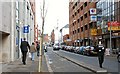
Upper Arthur Street, Belfast
Upper Arthur Street runs from May Street to Chichester Street. The rear entrance to the Ulster Bank head office is on the left. The red building on the right is a multi-storey car park.
Image: © Albert Bridge
Taken: 6 Mar 2008
0.01 miles