IMAGES TAKEN NEAR TO
William Street South, BELFAST, BT1 4AR
Introduction
This page details the photographs taken nearby to William Street South, BT1 4AR by members of the Geograph project.
The Geograph project started in 2005 with the aim of publishing, organising and preserving representative images for every square kilometre of Great Britain, Ireland and the Isle of Man.

There are currently over 7.5m images from over14,400 individuals and you can help contribute to the project by visiting https://www.geograph.org.uk
Image Map
Images are licensed for reuse under creativecommons.org/licenses/by-sa/2.0
Notes
- Clicking on the map will re-center to the selected point.
- The higher the marker number, the further away the image location is from the centre of the postcode.
Image Listing (3153 Images Found)
Images are licensed for reuse under creativecommons.org/licenses/by-sa/2.0
Image
Details
Distance
1
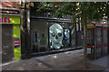
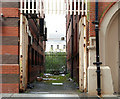
Victoria Square, Belfast (1)
See Image The development opened today amidst considerable publicity. This is the entrance from William Street South. Image shows how it looked just over five months ago.
Image: © Albert Bridge
Taken: 6 Mar 2008
0.01 miles
2
Arthur Place, Belfast
A short street running off Arthur Street towards the former Ross’s mineral water factory Image – now Argos.
Image: © Albert Bridge
Taken: 19 Apr 2009
0.01 miles
3
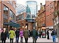
Montgomery Street, Belfast
Montgomery Street runs from May Street, across Chichester Street, to William Street South. This is the view from Chichester Street to William Street South. Most of the area was demolished to make way for the Victoria Square development Image (right and background). Littlewoods was in the background on the site of the new “Odeon”. Ross’s mineral water factory was at the far end, on the right, beyond the white van.
Image: © Albert Bridge
Taken: 3 Aug 2008
0.01 miles
4
Entry, Belfast
Running off Montgomery Street in the direction of Arthur Street. Not shown on the Google map.
Image: © Albert Bridge
Taken: 25 Oct 2009
0.01 miles
5
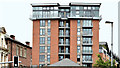
The Victoria Square apartments, Belfast (July 2014)
The Victoria Square development is best known for its dome Image and multi-level interior Image It does, however, also include apartments under the name “The Residence”. This view is from Donegall Square North, outside the City Hall grounds.
Image: © Albert Bridge
Taken: 13 Jul 2014
0.02 miles
6
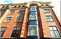
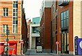
State Buildings, Belfast
Four storey office building, on the corner of Arthur Street and Arthur Place (this view), completed in 1902 to a design by Watt and Tulloch. The upper floor is a loggia.
Image: © Albert Bridge
Taken: 5 Jul 2009
0.02 miles
7
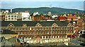
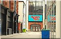
Former Ross's mineral water factory, Belfast
Using its own artesian well, Ross’s produced mineral waters at 1-7 Montgomery Street for almost 100 years until the mid 1970’s. The premises lay empty for a long time until extensively renovated as Ross’s Court, a shopping place on the lines of Covent Garden. To the casual visitor only the places selling food seemed to do any real business. It is now a super Argos. William Street South is at lower right. (Note: in the Belfast vernacular “a mineral” is a glass of lemonade). Continue to Image
Image: © Albert Bridge
Taken: 10 Jul 1981
0.02 miles
8
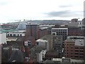
Belfast skyline
Looking north-east from the Belfast Wheel; the most famous object is the yellow Samson and Goliath cranes at Harland and Wolff's shipyard and the recent development at Victoria Square, which is the glass domed shaped building.
Image: © Kenneth Allen
Taken: 30 Mar 2009
0.02 miles
9
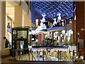
Victoria Square (night view), Belfast (November 2015)
Christmas decoration on display at Victoria Square. This view is from William Street South. Image shows a similar view on opening day (6 March 2008).
Image: © Albert Bridge
Taken: 11 Nov 2015
0.02 miles