IMAGES TAKEN NEAR TO
Aughnabrack Road, BELFAST, BT14 8SP
Introduction
This page details the photographs taken nearby to Aughnabrack Road, BT14 8SP by members of the Geograph project.
The Geograph project started in 2005 with the aim of publishing, organising and preserving representative images for every square kilometre of Great Britain, Ireland and the Isle of Man.

There are currently over 7.5m images from over14,400 individuals and you can help contribute to the project by visiting https://www.geograph.org.uk
Image Map
Images are licensed for reuse under creativecommons.org/licenses/by-sa/2.0
Notes
- Clicking on the map will re-center to the selected point.
- The higher the marker number, the further away the image location is from the centre of the postcode.
Image Listing (1 Images Found)
Images are licensed for reuse under creativecommons.org/licenses/by-sa/2.0
Image
Details
Distance
1
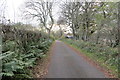
Aughnabrack Road
Another one where the road only just clipped the corner of the square for a few yards with no other access and another rare first visitor square. This time there were no convenient markers so I started photographing farther back up the road and took a picture every 10 yards or so till I was satisfied that I was through the square. Out of about 20 or so shots just one was in the right place!
Image: © Robert Ashby
Taken: 2 Nov 2014
0.11 miles