IMAGES TAKEN NEAR TO
Fairfax Court, BELFAST, BT14 7PB
Introduction
This page details the photographs taken nearby to Fairfax Court, BT14 7PB by members of the Geograph project.
The Geograph project started in 2005 with the aim of publishing, organising and preserving representative images for every square kilometre of Great Britain, Ireland and the Isle of Man.

There are currently over 7.5m images from over14,400 individuals and you can help contribute to the project by visiting https://www.geograph.org.uk
Image Map
Images are licensed for reuse under creativecommons.org/licenses/by-sa/2.0
Notes
- Clicking on the map will re-center to the selected point.
- The higher the marker number, the further away the image location is from the centre of the postcode.
Image Listing (39 Images Found)
Images are licensed for reuse under creativecommons.org/licenses/by-sa/2.0
Image
Details
Distance
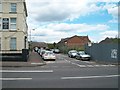
2
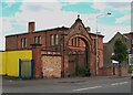
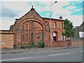
Surviving arch next to Barrett's Signs and Joinery
The industrial buildings which this arch provided access to have been demolished.
Image: © Eric Jones
Taken: 21 Jul 2014
0.09 miles
3
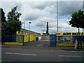
Car Wash on the site of demolished industrial buildings
Image: © Eric Jones
Taken: 21 Jul 2014
0.09 miles
4
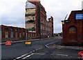
Ewarts Mill, Crumlin Road
Ewarts Mill, in the process of being demolished. Image made from the corner of Cambrai Street, which was also demolished at a later date. Cambrai St, is now part of the Edenderry Industrial complex.
Image: © Wilson Adams
Taken: Unknown
0.10 miles
5
Pooley weighbridge, Belfast
See Image A surviving (but disused) Pooley weighbridge in Belfast BT14. Full grid reference withheld as a courtesy to a trader who was very helpful.
Image: © Albert Bridge
Taken: 13 Sep 2011
0.10 miles
6
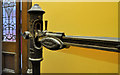
Pooley weighing machine, Belfast (1)
See Image A surviving (but disused) Pooley weighing machine (of the type once common at railway stations) in Belfast BT14. Full grid reference withheld as a courtesy to the owner who was very helpful.
Image: © Albert Bridge
Taken: 13 Sep 2011
0.10 miles
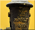
7
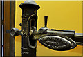
Pooley weighing machine, Belfast (2)
See Image The maker’s inscription which shows addresses of Liverpool and Glasgow. Full grid reference withheld as a courtesy to the owner who was very helpful.
Image: © Albert Bridge
Taken: 13 Sep 2011
0.10 miles
8
Pooley weighing machine, Belfast (3)
See Image The maker’s name. The plate showing the maximum weight is missing. Full grid reference withheld as a courtesy to the owner who was very helpful.
Image: © Albert Bridge
Taken: 13 Sep 2011
0.10 miles
10
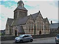
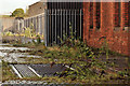
St Mary's Parish Church CoI, Crumlin Road
Built in the 1860s of sandstone and Mourne granite, St Mary's was designed in the gothic style with an enormous central tower and at a cost £6,500. The parish served an area dependent on the linen industry and suffered a decline when that industry collapsed in the 1960s. One of St Mary's more unusual parishioners was John Graham, Belfast Commander and Northern Director of Intelligence of the IRA in the 1940s. A staunch Protestant he successfully fought against the placing of a picture of the Virgin Mary in the church.
http://www.politics.ie/forum/history/194860-john-graham-protestant-ira-belfast-brigade-commander.html
Image: © Eric Jones
Taken: 21 Jul 2014
0.11 miles