IMAGES TAKEN NEAR TO
Etna Drive, BELFAST, BT14 7NN
Introduction
This page details the photographs taken nearby to Etna Drive, BT14 7NN by members of the Geograph project.
The Geograph project started in 2005 with the aim of publishing, organising and preserving representative images for every square kilometre of Great Britain, Ireland and the Isle of Man.

There are currently over 7.5m images from over14,400 individuals and you can help contribute to the project by visiting https://www.geograph.org.uk
Image Map
Images are licensed for reuse under creativecommons.org/licenses/by-sa/2.0
Notes
- Clicking on the map will re-center to the selected point.
- The higher the marker number, the further away the image location is from the centre of the postcode.
Image Listing (9 Images Found)
Images are licensed for reuse under creativecommons.org/licenses/by-sa/2.0
Image
Details
Distance
1
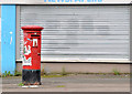
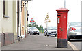
Pillar box, Glenard, Belfast
An EIIR pillar box at Alliance Avenue (foreground) near the corner of Etna Drive. The number is not visible but it should be BT14 201.
Image: © Albert Bridge
Taken: 23 Sep 2013
0.06 miles
2
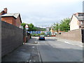
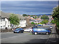
Berwick Road, Ardoyne, Belfast
Looking towards Alliance Avenue and the Peace Wall - in the 1960s, this was a mixed area (Protestants and Roman Catholics). In the times since a clear divide has been formed between Alliance Avenue and Glenbryn Park.
Image: © Dean Molyneaux
Taken: 26 Aug 2009
0.14 miles
3
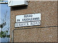
Bilingual signage, Berwick Road, Ardoyne
This is now an exclusively Roman Catholic area (not always so) - hence the use of for Irish street signs. I make no apologies for saying I am mystified as to why ratepayers' money goes into these - both for Irish and Ulster Scots. They seem to act more as 'territorial markers' than for Irish speakers.
Image: © Dean Molyneaux
Taken: 26 Aug 2009
0.14 miles
4
Alliance Avenue, Ardoyne, Belfast
Runs parallel to the 'Peace Wall'. This is only just on the Roman Catholic side.
Image: © Dean Molyneaux
Taken: 26 Aug 2009
0.19 miles
5
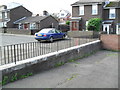
Velsheda Court, Ardoyne, Belfast
This was once all Velsheda Park - it has since been cut in two. An overwhelmingly Roman Catholic area - although in the 60s - it actually had a Protestant majority. Belfast really is 'no mean city'.
Image: © Dean Molyneaux
Taken: 26 Aug 2009
0.20 miles
6
Pillar box, Oldpark, Belfast (2)
GR pillar box (BT14 472) at Printworks Terrace on the Oldpark Road (opposite the Deerpark Road).
Image: © Albert Bridge
Taken: 23 Sep 2013
0.20 miles
7
Roadblock, Velsheda Park, Ardoyne
I believe these were used to separate streets as an attempt to stop joyriders coming down the hill - plaguing residents. If anyone knows otherwise - I'd like to hear.
Image: © Dean Molyneaux
Taken: 26 Aug 2009
0.20 miles
8
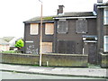
Dereliction, 37 Velsheda Court, Ardoyne
A sad sight - but common in North and West Belfast.
Image: © Dean Molyneaux
Taken: 26 Aug 2009
0.21 miles
9
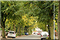
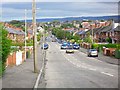
Alliance Avenue, Belfast
Quite a long (and by no means straight) street running from the Oldpark Road/Cliftonville Circus (behind me) to the Ardoyne Road. Developed after 1906 when it had four houses and Cliftonville showgrounds.
Image: © Albert Bridge
Taken: 23 Sep 2013
0.23 miles