IMAGES TAKEN NEAR TO
Crumlin Road, BELFAST, BT14 7GN
Introduction
This page details the photographs taken nearby to Crumlin Road, BT14 7GN by members of the Geograph project.
The Geograph project started in 2005 with the aim of publishing, organising and preserving representative images for every square kilometre of Great Britain, Ireland and the Isle of Man.

There are currently over 7.5m images from over14,400 individuals and you can help contribute to the project by visiting https://www.geograph.org.uk
Image Map
Images are licensed for reuse under creativecommons.org/licenses/by-sa/2.0
Notes
- Clicking on the map will re-center to the selected point.
- The higher the marker number, the further away the image location is from the centre of the postcode.
Image Listing (10 Images Found)
Images are licensed for reuse under creativecommons.org/licenses/by-sa/2.0
Image
Details
Distance
1
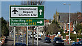
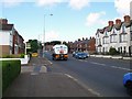
International Airport direction sign, Crumlin Road, Belfast (March 2016)
Once upon a time the Crumlin Road was the main road from Belfast to Aldergrove Airport and its predecessor at Nutt’s Corner Image The main way now, for most traffic, is via the M2 and Templepatrick Image On the other hand this is still the handiest way for many who live in north Belfast.
The sign is on the inward side of the Ballysillan Road. See also Image
Image: © Albert Bridge
Taken: 14 Mar 2016
0.03 miles
2
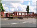
St. Gabriel's College, Ardoyne
A former Roman Catholic boys' school on the Crumlin Road. Owing to low enrollment - it sadly closed its doors in August 2008.
Image: © Dean Molyneaux
Taken: 25 Aug 2009
0.11 miles
3
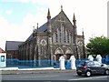
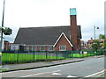
Ballysillan Presbyterian Church
At 773 Crumlin Road. Built in 1890 - in what was then a rural area. Interestingly - this church's design was copied in 1915, twenty miles away in Dromore, see: Image - practically identical!
Image: © Dean Molyneaux
Taken: 25 Aug 2009
0.13 miles
4
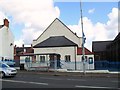
Gailey Memorial Hall, Ballysillan
Adjacent to Image at 773 Crumlin Road. Built in 1938 - forty-eight years after the church to which it belongs.
Image: © Dean Molyneaux
Taken: 25 Aug 2009
0.15 miles
5
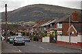
Crumlin Road at Glenside Park
In Belfast's Ballysillan area - BT14 as postal districts go. Looking up the hill towards Crumlin/International Airport.
Image: © Dean Molyneaux
Taken: 25 Aug 2009
0.15 miles
6
Glenside Park
Residential street on the Crumlin Road, the view is towards Divis Mountain. The Divis television transmitter mast can be seen top right.
Image: © Paul McIlroy
Taken: 6 Mar 2008
0.17 miles
7
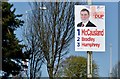
Assembly election poster, Crumlin Road, Belfast - April 2016(1)
Crumlin Road. Nelson McCausland, Paula Bradley and William Humphrey (Democratic Unionist Party).
Image: © Albert Bridge
Taken: 20 Apr 2016
0.20 miles
8
Holy Cross Girls Primary School, Ardoyne
When this school was built - the Ardoyne was a mixed (Protestant and R.C.) area. When The Troubles started and both communities moved to opposite sides of the neighbourhood - this Catholic school was left on the wrong side.
Unfortunately, in June 2001 tensions flared when local loyalist began to harass the school children and their parents while walking along the Protestant section of Ardoyne Road - eventually leading to the walk to school being undertaken between lines of riot police. The situation was eventually eased when children were permitted to enter via St Gabriel's College on the other side of the campus.
Image: © Dean Molyneaux
Taken: 26 Aug 2009
0.23 miles
9
Immanuel Parish Church, Ardoyne
Along Ardoyne Road at Glenbryn. This is a Church of Ireland (Anglican) congregation sited at an 'interface' - see Image
Image: © Dean Molyneaux
Taken: 26 Aug 2009
0.24 miles
10
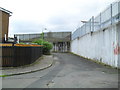
End of the Ardoyne Road
End of the line at Ballysillan.
Image: © Dean Molyneaux
Taken: 26 Aug 2009
0.24 miles