IMAGES TAKEN NEAR TO
Belmore Way, BELFAST, BT14 7BG
Introduction
This page details the photographs taken nearby to Belmore Way, BT14 7BG by members of the Geograph project.
The Geograph project started in 2005 with the aim of publishing, organising and preserving representative images for every square kilometre of Great Britain, Ireland and the Isle of Man.

There are currently over 7.5m images from over14,400 individuals and you can help contribute to the project by visiting https://www.geograph.org.uk
Image Map
Images are licensed for reuse under creativecommons.org/licenses/by-sa/2.0
Notes
- Clicking on the map will re-center to the selected point.
- The higher the marker number, the further away the image location is from the centre of the postcode.
Image Listing (3 Images Found)
Images are licensed for reuse under creativecommons.org/licenses/by-sa/2.0
Image
Details
Distance
1
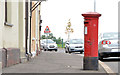
Pillar box, Oldpark, Belfast (2)
GR pillar box (BT14 472) at Printworks Terrace on the Oldpark Road (opposite the Deerpark Road).
Image: © Albert Bridge
Taken: 23 Sep 2013
0.09 miles
2
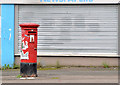
Pillar box, Glenard, Belfast
An EIIR pillar box at Alliance Avenue (foreground) near the corner of Etna Drive. The number is not visible but it should be BT14 201.
Image: © Albert Bridge
Taken: 23 Sep 2013
0.16 miles
3
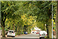
Alliance Avenue, Belfast
Quite a long (and by no means straight) street running from the Oldpark Road/Cliftonville Circus (behind me) to the Ardoyne Road. Developed after 1906 when it had four houses and Cliftonville showgrounds.
Image: © Albert Bridge
Taken: 23 Sep 2013
0.21 miles