IMAGES TAKEN NEAR TO
Glenburn Park, BELFAST, BT14 6TF
Introduction
This page details the photographs taken nearby to Glenburn Park, BT14 6TF by members of the Geograph project.
The Geograph project started in 2005 with the aim of publishing, organising and preserving representative images for every square kilometre of Great Britain, Ireland and the Isle of Man.

There are currently over 7.5m images from over14,400 individuals and you can help contribute to the project by visiting https://www.geograph.org.uk
Image Map
Images are licensed for reuse under creativecommons.org/licenses/by-sa/2.0
Notes
- Clicking on the map will re-center to the selected point.
- The higher the marker number, the further away the image location is from the centre of the postcode.
Image Listing (3 Images Found)
Images are licensed for reuse under creativecommons.org/licenses/by-sa/2.0
Image
Details
Distance
1
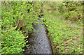
The Milewater, Belfast
Not named on the 1:12,000 map but this seems to be the Milewater – a stream which rises on the side of the Cave Hill and flows through Carr’s Glen. It continues, partly underground, to the Waterworks Image before encountering saltwater at Belfast harbour. This view is upstream from this bridge Image on the Old Westland Road.
Image: © Albert Bridge
Taken: 5 May 2013
0.09 miles
2
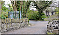
Narrow bridge, Belfast
A bridge, just about wide enough for a car, across the Milewater Image on the Old Westland Road. There is a separate pedestrian bridge just out of picture of the right. Name unknown but the Roads Service seems to refer to it as “Bridge 20151”.
Image: © Albert Bridge
Taken: 5 May 2013
0.10 miles
3
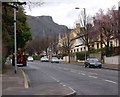
The Cavehill Road
The Cavehill Road is a residential road which runs from the Antrim Road to the Ballysillan Road. This view is towards the Cavehill.
Image: © Paul McIlroy
Taken: 6 Mar 2008
0.12 miles