IMAGES TAKEN NEAR TO
Kelvin Parade, BELFAST, BT14 6NB
Introduction
This page details the photographs taken nearby to Kelvin Parade, BT14 6NB by members of the Geograph project.
The Geograph project started in 2005 with the aim of publishing, organising and preserving representative images for every square kilometre of Great Britain, Ireland and the Isle of Man.

There are currently over 7.5m images from over14,400 individuals and you can help contribute to the project by visiting https://www.geograph.org.uk
Image Map
Images are licensed for reuse under creativecommons.org/licenses/by-sa/2.0
Notes
- Clicking on the map will re-center to the selected point.
- The higher the marker number, the further away the image location is from the centre of the postcode.
Image Listing (18 Images Found)
Images are licensed for reuse under creativecommons.org/licenses/by-sa/2.0
Image
Details
Distance
1
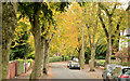
Kingsmere Avenue, Belfast
A street, built in the very early 20th century, running from the Cliftonville Road (behind me), across Cardigan Drive (lower middle), to Knutsford Drive (which borders the Waterworks Image). The trees are showing the first signs of autumn colour.
Image: © Albert Bridge
Taken: 23 Sep 2013
0.06 miles
2
![Antrim Road Waterworks [2]](https://s3.geograph.org.uk/photos/49/79/497907_6fd94ed9_120x120.jpg)
Antrim Road Waterworks [2]
Antrim Road Waterworks - this is the upper pond looking towards Divis and Black Mountain. Cliftonville's football ground Solitude is visible just behind the pond.
The Waterworks, as the name suggests, was the source of Belfast`s water supply in the mid 1800s. The growing city soon outpaced supply however and the site was eventually used for recreation. It became a public park in the 1950s.
Image: © Rossographer
Taken: 18 Jul 2007
0.10 miles
3
![Antrim Road Waterworks [3]](https://s1.geograph.org.uk/photos/49/79/497909_b4f75a11_120x120.jpg)
Antrim Road Waterworks [3]
Another view of the upper pond at the Waterworks, looking towards Cave Hill.
The Waterworks, as the name suggests, was the source of Belfast`s water supply in the mid 1800s. The growing city soon outpaced supply however and the site was eventually used for recreation. It became a public park in the 1950s.
Image: © Rossographer
Taken: 18 Jul 2007
0.10 miles
4
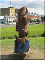
Wooden Fish
Wooden fish sculpture at the Waterworks park.
Image: © Rossographer
Taken: 18 Jul 2007
0.10 miles
5
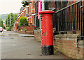
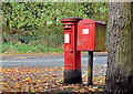
Pillar box, Belfast
GVIR pillar box (BT14 222), on the Cliftonville Road, at the corner of Cardigan Drive (right).
Image: © Albert Bridge
Taken: 5 Aug 2012
0.13 miles
6
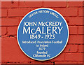
John McCredy McAlery plaque, Belfast
A recently-erected plaque, at “Solitude” (Cliftonville’s ground at Cliftonville Street), commemorating John McCredy McAlery http://www.ulsterhistory.co.uk/mcalery.html who founded the club.
Image: © Albert Bridge
Taken: 23 Sep 2013
0.16 miles
7
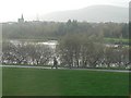
Belfast: looking across Antrim Road Waterworks
The view from the top floor of 117 Cavehill Road, across Image, now a public park.
Image: © Chris Downer
Taken: 10 Nov 2007
0.17 miles
8
Pillar box and drop box, Belfast
Drop box and GR pillar box (BT14 440), on the Westland Road, at Knutsford Drive.
Image: © Albert Bridge
Taken: 20 Oct 2012
0.17 miles
9
Solitude football ground, Belfast (June 2014)
An outside view of the Main Stand at Solitude http://en.wikipedia.org/wiki/Solitude_(Belfast) – home to Cliftonville Image
Image: © Albert Bridge
Taken: 17 Jun 2014
0.17 miles
10
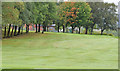
Cliftonville golf course, Belfast
See Image (June 2007). Part of the nine-hole course seen from the Westland Road, to the south west of Knutsford Drive. Beware – there is a website, with the course’s name, which has no visible connection to the club or even golf.
Image: © Albert Bridge
Taken: 23 Sep 2013
0.19 miles