IMAGES TAKEN NEAR TO
Cliftonville Road, BELFAST, BT14 6JX
Introduction
This page details the photographs taken nearby to Cliftonville Road, BT14 6JX by members of the Geograph project.
The Geograph project started in 2005 with the aim of publishing, organising and preserving representative images for every square kilometre of Great Britain, Ireland and the Isle of Man.

There are currently over 7.5m images from over14,400 individuals and you can help contribute to the project by visiting https://www.geograph.org.uk
Image Map
Images are licensed for reuse under creativecommons.org/licenses/by-sa/2.0
Notes
- Clicking on the map will re-center to the selected point.
- The higher the marker number, the further away the image location is from the centre of the postcode.
Image Listing (17 Images Found)
Images are licensed for reuse under creativecommons.org/licenses/by-sa/2.0
Image
Details
Distance
1
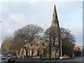
Belfast: Antiochian Orthodox Church of St. Ignatius
Situated on the corner of Antrim Road and Cliftonville Road.
Image: © Chris Downer
Taken: 10 Nov 2007
0.01 miles
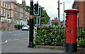
2
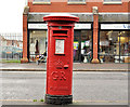
Pillar box, Belfast
GR pillar box, on the eastern side of the Antrim Road, between Duncairn Avenue and the Cliftonville Road.
Image: © Albert Bridge
Taken: 21 Nov 2011
0.09 miles
3
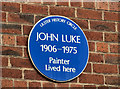
John Luke (painter) plaque, Belfast
A plaque, on a block of flats, at the Antrim Road end of Duncairn Gardens, commemorating the painter John Luke http://www.ulsterhistory.co.uk/johnluke.htm. This link shows some of his work http://www.bbc.co.uk/arts/yourpaintings/artists/john-luke/paintings/slideshow. See also Image
Image: © Albert Bridge
Taken: 6 Jun 2012
0.09 miles
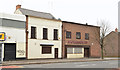
4
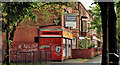
No 210 Duncairn Gardens, Belfast
A vacant property, at the corner of Duncairn Gardens and Halliday’s Road (left) offered for sale as a development opportunity. According to the agent’s website “Planning was previously approved for a small mixed use scheme”. This photograph appears as a matter of record only. I have no connection with any of the properties involved in the sale.
Image: © Albert Bridge
Taken: 6 Jun 2012
0.09 miles
5
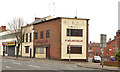
Former McLaughlin's Bar, Belfast - March 2014(1)
The view from the south with Halliday’s Road on the right.
Image: © Albert Bridge
Taken: 30 Mar 2014
0.10 miles
6
Former McLaughlin's Bar, Belfast - March 2014(2)
The view from the north west.
Image: © Albert Bridge
Taken: 30 Mar 2014
0.10 miles
7

Louis MacNeice plaque, Belfast
See Image (January 2007). A plaque (behind a fence – bottom) at the poet’s http://www.ulsterhistory.co.uk/louismcneice.htm birthplace, 2 Brookhill Avenue, Cliftonville Road. See also Image (December 2011).
Image: © Albert Bridge
Taken: 29 Sep 2013
0.15 miles
8
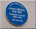
Chaim Herzog plaque, Belfast
A plaque, near the Cliftonville Road end of Cliftonpark Avenue, marking the birthplace of Chaim Herzog, sixth president of Israel. Three links – a biography http://www.zionism-israel.com/bio/Chaim_Herzog_biography.htm, a speech http://www.youtube.com/watch?v=7BxMvnWrmh0 and the plaque http://www.ulsterhistory.co.uk/chaimherzog.htm.
Very close to the edge of the grid square.
Image: © Albert Bridge
Taken: 24 Jul 2012
0.17 miles
9
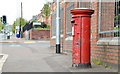
Pillar box, Belfast
EIIR pillar box (BT14 92) on the Cliftonville Road, close to Cliftonville Avenue.
Image: © Albert Bridge
Taken: 16 May 2013
0.18 miles
10
Pillar box, Belfast
GVIR pillar box, on the Antrim Road just past Dawson Street.
Image: © Albert Bridge
Taken: 23 May 2011
0.20 miles