IMAGES TAKEN NEAR TO
Cliftonville Road, BELFAST, BT14 6JQ
Introduction
This page details the photographs taken nearby to Cliftonville Road, BT14 6JQ by members of the Geograph project.
The Geograph project started in 2005 with the aim of publishing, organising and preserving representative images for every square kilometre of Great Britain, Ireland and the Isle of Man.

There are currently over 7.5m images from over14,400 individuals and you can help contribute to the project by visiting https://www.geograph.org.uk
Image Map
Images are licensed for reuse under creativecommons.org/licenses/by-sa/2.0
Notes
- Clicking on the map will re-center to the selected point.
- The higher the marker number, the further away the image location is from the centre of the postcode.
Image Listing (20 Images Found)
Images are licensed for reuse under creativecommons.org/licenses/by-sa/2.0
Image
Details
Distance
1
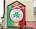
"Cliftonville" mural, Belfast (1)
A mural, on the Cliftonville Road, at the corner of Oldpark Avenue, in honour of Cliftonville http://www.cliftonvillefc.net/ and http://en.wikipedia.org/wiki/Cliftonville_F.C. the oldest team in the Irish League. See also Image
Image: © Albert Bridge
Taken: 23 Sep 2013
0.07 miles
2
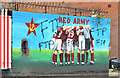
"Cliftonville" mural, Belfast (2)
See Image An earlier mural beside the previous one.
Image: © Albert Bridge
Taken: 23 Sep 2013
0.07 miles
3
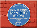
John McCredy McAlery plaque, Belfast
A recently-erected plaque, at “Solitude” (Cliftonville’s ground at Cliftonville Street), commemorating John McCredy McAlery http://www.ulsterhistory.co.uk/mcalery.html who founded the club.
Image: © Albert Bridge
Taken: 23 Sep 2013
0.09 miles
4
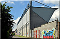
Solitude football ground, Belfast (June 2014)
An outside view of the Main Stand at Solitude http://en.wikipedia.org/wiki/Solitude_(Belfast) – home to Cliftonville Image
Image: © Albert Bridge
Taken: 17 Jun 2014
0.11 miles
5
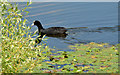
Coot and water lilies, the Waterworks, Belfast (June 2014)
Feather-footed through the water lilies Image passes the questing coot (with acknowledgement to William Boot).
Image: © Albert Bridge
Taken: 17 Jun 2014
0.13 miles
6
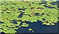
Water lilies, the Waterworks, Belfast (June 2014)
Part of a large growth of water lilies at the south western side of the pond.
Image: © Albert Bridge
Taken: 17 Jun 2014
0.13 miles
7
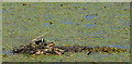
Nesting coot, the Waterworks, Belfast (June 2014)
A coot, on its nest among the water lilies, at the south western side of the pond.
Image: © Albert Bridge
Taken: 17 Jun 2014
0.14 miles
8
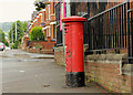
Pillar box, Belfast
GVIR pillar box (BT14 222), on the Cliftonville Road, at the corner of Cardigan Drive (right).
Image: © Albert Bridge
Taken: 5 Aug 2012
0.15 miles
9
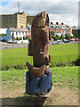
Wooden Fish
Wooden fish sculpture at the Waterworks park.
Image: © Rossographer
Taken: 18 Jul 2007
0.16 miles
10
![Antrim Road Waterworks [3]](https://s1.geograph.org.uk/photos/49/79/497909_b4f75a11_120x120.jpg)
Antrim Road Waterworks [3]
Another view of the upper pond at the Waterworks, looking towards Cave Hill.
The Waterworks, as the name suggests, was the source of Belfast`s water supply in the mid 1800s. The growing city soon outpaced supply however and the site was eventually used for recreation. It became a public park in the 1950s.
Image: © Rossographer
Taken: 18 Jul 2007
0.16 miles