1
A block of shops on Crumlin Street
These are located between the Century Street junction and Oldpark Road junction. The image was taken from the Crimea Street junction.
Image: © Eric Jones
Taken: 21 Jul 2014
0.07 miles
2
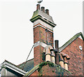
Former Ulster Bank, Crumlin Road, Belfast - January 2017(2)
Two chimneys and seven varied pots at the south eastern end of the former bank.
Image: © Albert Bridge
Taken: 15 Jan 2017
0.08 miles
3
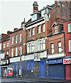
Former Ulster Bank, Crumlin Road, Belfast - January 2017(1)
The former Ulster Bank, now without signs or other identification and recognisable only by the shutters in Ulster Bank corporate blue. Last seen (when open) in July 2014
Image
Image: © Albert Bridge
Taken: 15 Jan 2017
0.08 miles
4
Clifton Park Avenue Baptist church, Belfast (September 2014)
A Baptist church, on the north western side of Cliftonpark Avenue, built circa 1901/07 to a design by James Hanna. It seems to have been called a Baptist hall at the time of construction. Note the two spellings.
Image: © Albert Bridge
Taken: 10 Sep 2014
0.08 miles
5
The Vine Centre, Crumlin Road
This is a community advice centre run on a Christian ethos.
Image: © Eric Jones
Taken: 21 Jul 2014
0.08 miles
6
Century Street off the Crumlin Road
The building on the right is the Vine Centre - an advice and community centre and that in the background is Ebenezer Gospel Hall.
Image: © Eric Jones
Taken: 21 Jul 2014
0.08 miles
7
View across Crumlin Road to Cliftonpark Avenue
The image taken from Agnes Street shows, on the left, Cliftonpark Avenue Baptist Church.
Image: © Eric Jones
Taken: 21 Jul 2014
0.09 miles
8
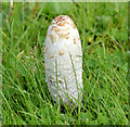
Shaggy ink cap, Belfast (September 2014)
One of several shaggy ink caps growing on the Cliftonpark Avenue side of this site
Image
Image: © Albert Bridge
Taken: 10 Sep 2014
0.10 miles
9
Millworkers sculpture, Belfast (2)
See
Image A close look at the two figures. The one on the left is wearing a shawl – something which, while by then relatively rare, nevertheless continued into the late 1960’s.
Image: © Albert Bridge
Taken: 13 Sep 2011
0.10 miles
10
Millgirl statues on the corner of Snugville Street and Crumlin Road
Carved on the base of the second statue are names of the three huge mills which operated on this stretch of Crumlin Road - Ewarts, Edenderry and Brookfield.
Image: © Eric Jones
Taken: 21 Jul 2014
0.10 miles


