IMAGES TAKEN NEAR TO
Laganbank Road, BELFAST, BT1 3LX
Introduction
This page details the photographs taken nearby to Laganbank Road, BT1 3LX by members of the Geograph project.
The Geograph project started in 2005 with the aim of publishing, organising and preserving representative images for every square kilometre of Great Britain, Ireland and the Isle of Man.

There are currently over 7.5m images from over14,400 individuals and you can help contribute to the project by visiting https://www.geograph.org.uk
Image Map
Images are licensed for reuse under creativecommons.org/licenses/by-sa/2.0
Notes
- Clicking on the map will re-center to the selected point.
- The higher the marker number, the further away the image location is from the centre of the postcode.
Image Listing (747 Images Found)
Images are licensed for reuse under creativecommons.org/licenses/by-sa/2.0
Image
Details
Distance
1
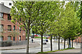
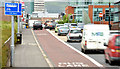
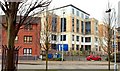
The Laganbank Road, Belfast (May 2016)
The view along the Laganbank Road from the East Bridge Street end. Note the tree growth since this view Image in September 2008.
Image: © Albert Bridge
Taken: 15 May 2016
0.01 miles
2
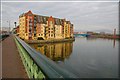
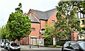
Apartments, St John's Wharf, Belfast
This block of apartments is between the Laganbank Road and the Lagan. The Albert Bridge Image is in the foreground.
Image: © Albert Bridge
Taken: 6 Oct 2007
0.02 miles
3
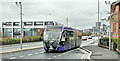
Glider bus, East Bridge Street, Belfast - March 2019(1)
Glider Van Hool Equi City bus (3215 HGZ 8215), approaching the Laganbank Road with a Poleglass - Dundonald service.
The former Central station (left) has been renovated many times Image Image Image and is now called Lanyon Place.
Image: © Albert Bridge
Taken: 16 Mar 2019
0.02 miles
4
The rear of St John's Wharf Apartments from Laganbank Road
Image: © Eric Jones
Taken: 3 Nov 2014
0.02 miles
5
Bus lane, East Bridge Street, Belfast (EWAY) - June 2014(1)
The 24 hour inward bus lane, as it approaches Central station. Some years ago Translink changed the arrangements for taxis at the station. The rank is now contracted to a specific operator of private-hire vehicles. Public-hire (black) taxis now use the bus lane to pick up and set down and sometimes, especially pending the arrival of the “Enterprise”, for waiting.
Image: © Albert Bridge
Taken: 9 Jun 2014
0.03 miles
6
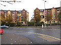
No 5 Laganbank Road, Belfast - May 2019(1)
The Laganbank Road side of the former night club.
Image: © Albert Bridge
Taken: 19 May 2019
0.03 miles
7
"El Divino", Belfast
Bar/nightclub (formerly “The Edge”) on the Laganbank Road, between St John’s Wharf Image (left) and the Waterfront Plaza Image Built on (or very close to) the site of the old mortuary.
Image: © Albert Bridge
Taken: 19 May 2014
0.04 miles
8
The Laganbank Road, Belfast (2)
See Image The Laganbank Road from the Albert Bridge end. The railway bridge Image is the blue line to the left of the trees in the background. The flats on the left occupy part of the site of the (now demolished) East Bridge Street power station (built 1898). For a comparison in tree growth see Image
Image: © Albert Bridge
Taken: 14 Sep 2008
0.04 miles
9
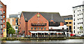
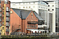
The Lesley Exchange, Belfast
The Lesley Exchange is an office development built in two phases in the late 90’s and early part of this century. It fronts onto East Bridge Street. This is the rear view from the Laganbank Road.
Image: © Albert Bridge
Taken: 16 Mar 2008
0.04 miles
10
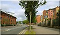
No 5 Laganbank Road, Belfast - February 2018(1)
The building, across the Lagan, from the east.
Image: © Albert Bridge
Taken: 11 Feb 2018
0.04 miles