IMAGES TAKEN NEAR TO
Lanyon Quay, BELFAST, BT1 3LG
Introduction
This page details the photographs taken nearby to Lanyon Quay, BT1 3LG by members of the Geograph project.
The Geograph project started in 2005 with the aim of publishing, organising and preserving representative images for every square kilometre of Great Britain, Ireland and the Isle of Man.

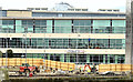
There are currently over 7.5m images from over14,400 individuals and you can help contribute to the project by visiting https://www.geograph.org.uk
Image Map
Images are licensed for reuse under creativecommons.org/licenses/by-sa/2.0
Notes
- Clicking on the map will re-center to the selected point.
- The higher the marker number, the further away the image location is from the centre of the postcode.
Image Listing (2671 Images Found)
Images are licensed for reuse under creativecommons.org/licenses/by-sa/2.0
Image
Details
Distance
1
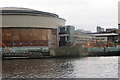
The Waterfront Hall, Belfast - May 2014(8)
Excavation work along this part of Lanyon Quay Image
Image: © Albert Bridge
Taken: 19 May 2014
0.01 miles
2
The Waterfront Hall, Belfast - May 2014(9)
Most of the site, along this part of Lanyon Quay Image, seen from the Queen’s Bridge.
Image: © Albert Bridge
Taken: 19 May 2014
0.01 miles
3
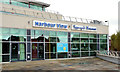
Restaurant to let, Belfast (2)
A restaurant to let at Unit 1A, Lanyon Quay.
Image: © Albert Bridge
Taken: 14 Oct 2012
0.01 miles
4
Belfast City
Looking north near Oxford Street
Image: © Kenneth Allen
Taken: 8 Mar 2010
0.01 miles
5
Building work
A new conference centre being added to the Waterfront Hall under construction beside the River Lagan.
Image: © Robert Ashby
Taken: 17 Nov 2014
0.01 miles
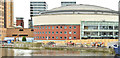
6
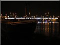
Belfast: the Confiance moored on the Lagan
Looking north (downstream) along the Lagan, this ship is moored near the Waterfront Hall. Queen’s Bridge can be seen illuminated in the background (see also Image).
The ship arrived in Belfast on 3 November 2006 and, in 2008, a heritage centre will open on board, illustrating the shipbuilding history of the city.
Image: © Chris Downer
Taken: 10 Nov 2007
0.02 miles
7
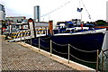
Belfast City Centre - Dutch Barge Confiance (Museum)
View is to the north from the west bank of the River Lagan.
Image: © Joseph Mischyshyn
Taken: 23 Sep 2013
0.02 miles
8
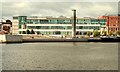
Lanyon Quay, Belfast
A mixed use building, of offices and restaurants, completed in 2004 as part of the Laganside scheme. Built on a site between what was the Laganbank Road and Oxford Street. Architects WD&RT Taggart.
Image: © Albert Bridge
Taken: 17 Aug 2009
0.02 miles
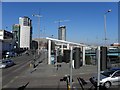
9
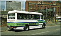
Flexibus, Belfast (1990)
A Flexibus Mercedes minibus parked on the Laganbank Road, at the back of Oxford Street bus station. The area was subsequently redeveloped as Lanyon Quay. This part of the Laganbank Road ceased to exist. Image shows (approximately) the same view, 21 years later, in 2011.
Image: © Albert Bridge
Taken: 4 Jun 1990
0.02 miles
10
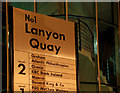
Sign, Lanyon Quay, Belfast
Part of the sign showing the occupants of no 1 Lanyon Quay Image
Image: © Albert Bridge
Taken: 11 Nov 2009
0.02 miles