IMAGES TAKEN NEAR TO
Princes Street, BELFAST, BT1 3FN
Introduction
This page details the photographs taken nearby to Princes Street, BT1 3FN by members of the Geograph project.
The Geograph project started in 2005 with the aim of publishing, organising and preserving representative images for every square kilometre of Great Britain, Ireland and the Isle of Man.

There are currently over 7.5m images from over14,400 individuals and you can help contribute to the project by visiting https://www.geograph.org.uk
Image Map
Images are licensed for reuse under creativecommons.org/licenses/by-sa/2.0
Notes
- Clicking on the map will re-center to the selected point.
- The higher the marker number, the further away the image location is from the centre of the postcode.
Image Listing (3433 Images Found)
Images are licensed for reuse under creativecommons.org/licenses/by-sa/2.0
Image
Details
Distance
1
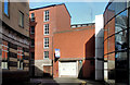
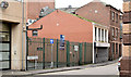
Marlborough Street site, Belfast (2)
The agent’s board now includes the word “reduced”.
Image: © Albert Bridge
Taken: 16 Sep 2012
0.01 miles
2
Vacant site, Donegall Quay, Belfast (1990)
The view, west, across Donegall Quay. From left to right: (upper) Churchill House, Victoria Square Image – now demolished, (below) the blue building is this one Image – then occupied, the vacant site later became the Laganside Buscentre Image and multi-storey car park Image, (next right) Lagan House, Victoria Street Image – since re-clad, (middle right) this building, Victoria Street Image which, after an extensive restoration became the Malmaison Hotel and (right) Marlborough House, Victoria Street/Marlborough Street – later modernised and re-clad Image
Image: © Albert Bridge
Taken: 13 May 1990
0.02 miles
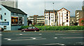
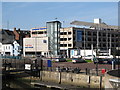
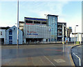
3
The Laganside Buscentre, Belfast (under construction) (1)
The Laganside Buscentre Image is housed on the ground floor of the multi-storey car park at Donegall Quay Image This view shows the building under construction. See also Image
Image: © Albert Bridge
Taken: 2 Apr 1995
0.02 miles
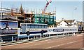
4
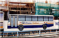
The Laganside Buscentre, Belfast (under construction) (2)
See Image A close look at the “Goldliner” poster.
Image: © Albert Bridge
Taken: 2 Apr 1995
0.02 miles
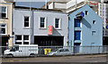
5
Development site, Prince's Street, Belfast (November 2014)
A vacant site on the eastern side of Prince’s Street forming part of the back of Jamison & Green Image, Ann Street. For reference purposes the Laganside Buscentre Image is on the left. The First Trust Bank Image intrudes on the right.
Image: © Albert Bridge
Taken: 9 Nov 2014
0.02 miles
6
Laganside Bus Centre, Donegall Quay
The bus station occupies the lower floor, with the floors above being the Donegall Quay Car Park. Ulterbus services for Co Antrim and NE Down use the station.
Image: © Eric Jones
Taken: 21 May 2012
0.02 miles
7
No 9 Donegall Quay, Belfast (2013)
The vacant building facing Donegall Quay.
Image: © Albert Bridge
Taken: 13 Sep 2013
0.02 miles
8
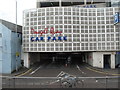
Donegall Quay Car Park
This stands next door to the Laganside Ulsterbus Station
Image: © Eric Jones
Taken: 26 Jun 2017
0.02 miles
9
Donegall Quay Car Park, Belfast
Pictured along Donegall Quay
Image: © Kenneth Allen
Taken: 18 Dec 2017
0.02 miles
10
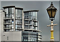
"The Boat", Belfast (2)
Just over a year since the last photograph of this building Image (May 2011). The light (mid-afternoon) today was unusual. Had it been January I’d have said that snow was on the way. The view is from the walkway, close to the Queen’s Bridge. Continue to Image (October 2012).
Image: © Albert Bridge
Taken: 13 Jun 2012
0.03 miles