IMAGES TAKEN NEAR TO
Pilot Street, BELFAST, BT1 3EP
Introduction
This page details the photographs taken nearby to Pilot Street, BT1 3EP by members of the Geograph project.
The Geograph project started in 2005 with the aim of publishing, organising and preserving representative images for every square kilometre of Great Britain, Ireland and the Isle of Man.

There are currently over 7.5m images from over14,400 individuals and you can help contribute to the project by visiting https://www.geograph.org.uk
Image Map
Images are licensed for reuse under creativecommons.org/licenses/by-sa/2.0
Notes
- Clicking on the map will re-center to the selected point.
- The higher the marker number, the further away the image location is from the centre of the postcode.
Image Listing (777 Images Found)
Images are licensed for reuse under creativecommons.org/licenses/by-sa/2.0
Image
Details
Distance
1
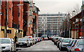
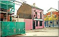
Pilot Street, Belfast (2)
See Image The view in the opposite direction. The Pilot Street apartments Image are about half-way along on the left with the “Rotterdam” Image just beyond. The Abercorn Basin Image is in the background.
Image: © Albert Bridge
Taken: 5 Feb 2010
0.00 miles
2
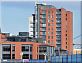
Pilot Street Apartments, Belfast (November 2014)
The Pilot Street Apartments seen from Donegall Quay. When viewed from Queen’s Quay some of the building has been hidden from view by the construction of CQ1 in the City Quays development http://www.geograph.org.uk/snippet/3872. This view seems likely to remain unchanged (except for the blue fence).
Image: © Albert Bridge
Taken: 16 Nov 2014
0.01 miles
3
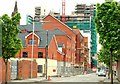
Pilot Street apartments, Belfast
When complete there will be 135 apartments in the area once known as “Sailortown”. One interesting feature is that their height increases gradually from west to east. The only remaining prominent landmark from the old Sailortown – the disused St Joseph’s church Image can be seen at top left. Continue to Image
Image: © Albert Bridge
Taken: 17 May 2009
0.01 miles
4
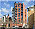
Pilot Street Apartments, Belfast (March 2018)
The apartments from beside the Clarendon Dock.
Image: © Albert Bridge
Taken: 24 Mar 2018
0.01 miles
5
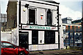
Former "Rotterdam Bar", Belfast (March 2016)
The former “Rotterdam Bar” still standing, at the south eastern end of Pilot Street, awaiting some future redevelopment of the surrounding area. The first of this series was in May 2009 Image
Image: © Albert Bridge
Taken: 30 Mar 2016
0.01 miles
6
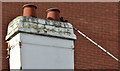
Chimney, former "Rotterdam Bar", Belfast (March 2016)
A chimney, with two pots, on the former “Rotterdam Bar” Image, Pilot Street.
Image: © Albert Bridge
Taken: 30 Mar 2016
0.02 miles
7
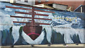
Tall ships mural, Belfast (March 2016)
A mural, on the side of the former “Rotterdam Bar” Image, marking the Tall Ships Belfast 2015/Belfast Titanic Maritime Festival http://www.geograph.org.uk/snippet/13820. It replaced this one Image
Image: © Albert Bridge
Taken: 30 Mar 2016
0.02 miles
8

Pilot Street apartments, Belfast (3)
See Image The apartments (looking much bigger than in the previous photo) seen from Queen’s Quay, on the other side of the Lagan. Continue to Image
Image: © Albert Bridge
Taken: 27 Sep 2009
0.02 miles
9
The Rotterdam Bar, Belfast
Tucked away at the south eastern end of Pilot Street, between the new apartments Image (left) and the Clarendon Dock offices Image (right) the bar is known for its live music. Dating from 1797 it was (and possibly still is) under threat of demolition and replacement by more apartments - see Image
Image: © Albert Bridge
Taken: 17 May 2009
0.02 miles
10
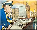
Mural, Sailortown, Belfast (2)
See Image That part of the mural depicting the receipt of the news of the sinking of the “Titanic”. For another "Titanic" mural see Image
Image: © Albert Bridge
Taken: 17 May 2009
0.02 miles