IMAGES TAKEN NEAR TO
Ballygomartin Road, BELFAST, BT13 3QX
Introduction
This page details the photographs taken nearby to Ballygomartin Road, BT13 3QX by members of the Geograph project.
The Geograph project started in 2005 with the aim of publishing, organising and preserving representative images for every square kilometre of Great Britain, Ireland and the Isle of Man.

There are currently over 7.5m images from over14,400 individuals and you can help contribute to the project by visiting https://www.geograph.org.uk
Image Map
Images are licensed for reuse under creativecommons.org/licenses/by-sa/2.0
Notes
- Clicking on the map will re-center to the selected point.
- The higher the marker number, the further away the image location is from the centre of the postcode.
Image Listing (2 Images Found)
Images are licensed for reuse under creativecommons.org/licenses/by-sa/2.0
Image
Details
Distance
1
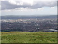
Looking East over Belfast from Black Mountain
Scrabo Hill (Newtownards) & Strangford Lough in far background (at RHS).
Image: © Norman Ekin
Taken: 30 Jul 2006
0.12 miles
2
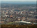
Belfast from Black Mountain
The view east from Black Mountain offers an excellent view over Belfast.
Beyond part of the mountain and the two people can be seen part of west Belfast. Beyond can be seen the high rise buildings of central Belfast with the terraces of east Belfast behind. Dundonald is behind those and in the far distance you can just see the town of Comber with Scrabo Tower visible in the top left. Strangford Lough and the Ards Peninsula are in the far distance.
Image: © Rossographer
Taken: 12 Apr 2009
0.20 miles