IMAGES TAKEN NEAR TO
Glencairn Road, BELFAST, BT13 3PU
Introduction
This page details the photographs taken nearby to Glencairn Road, BT13 3PU by members of the Geograph project.
The Geograph project started in 2005 with the aim of publishing, organising and preserving representative images for every square kilometre of Great Britain, Ireland and the Isle of Man.

There are currently over 7.5m images from over14,400 individuals and you can help contribute to the project by visiting https://www.geograph.org.uk
Image Map
Images are licensed for reuse under creativecommons.org/licenses/by-sa/2.0
Notes
- Clicking on the map will re-center to the selected point.
- The higher the marker number, the further away the image location is from the centre of the postcode.
Image Listing (4 Images Found)
Images are licensed for reuse under creativecommons.org/licenses/by-sa/2.0
Image
Details
Distance
1
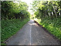
View east along Glencairn Road
This road rises up the lower slopes of the Belfast Mountains above the suburb of Ballygomartin.
Image: © Eric Jones
Taken: 19 May 2012
0.11 miles
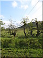
3
Power lines approaching Glencairn Road from the north
The Belfast suburb of Ligoniel can be seen in the background
Image: © Eric Jones
Taken: 19 May 2012
0.21 miles
4
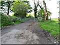
Gate at the top end of Glencairn Road
This is as far as traffic can go. However, a gap is provided for walkers to go through. The wreath of poppies on the tree is in memory of Martin Young.
Image: © Eric Jones
Taken: 19 May 2012
0.25 miles