IMAGES TAKEN NEAR TO
Woodvale Drive, BELFAST, BT13 3LN
Introduction
This page details the photographs taken nearby to Woodvale Drive, BT13 3LN by members of the Geograph project.
The Geograph project started in 2005 with the aim of publishing, organising and preserving representative images for every square kilometre of Great Britain, Ireland and the Isle of Man.

There are currently over 7.5m images from over14,400 individuals and you can help contribute to the project by visiting https://www.geograph.org.uk
Image Map
Images are licensed for reuse under creativecommons.org/licenses/by-sa/2.0
Notes
- Clicking on the map will re-center to the selected point.
- The higher the marker number, the further away the image location is from the centre of the postcode.
Image Listing (41 Images Found)
Images are licensed for reuse under creativecommons.org/licenses/by-sa/2.0
Image
Details
Distance
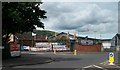
1
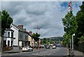
The northern end of Woodvale Road
The road is approaching the junction with Crumlin Road and the interface witho the staunchly Nationalist Ardoyne area.
Image: © Eric Jones
Taken: 21 Jul 2014
0.05 miles
2
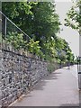
Peace fence separating Holy Cross Roman Catholic Church from the Portestant Woodvale Road
Holy Cross Church on Crumlin Road is the main place of worship for the Catholic population of the Ardoyne.
Image: © Eric Jones
Taken: 21 Jul 2014
0.05 miles
3
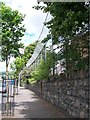
The interface between the Woodvale and the Ardoyne areas
The Woodvale Ward is 86.96% Protestant and the Ardoyne Ward is 92.83% Roman Catholic. Tension between the two cultures is locally high.
Image: © Eric Jones
Taken: 21 Jul 2014
0.06 miles
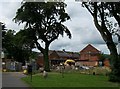
4
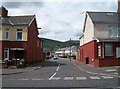
Woodvale Parade viewed from Woodvale Road
The transmitter masts on Divis can be seen in the background. Woodvale Parade has housing dating mainly from the post-WWII period.
Image: © Eric Jones
Taken: 21 Jul 2014
0.07 miles
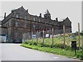
5
The former Holy Cross School
These buildings have been replaced by modern school buildings elsewhere in the Ardoyne.
Image: © Eric Jones
Taken: 21 Jul 2014
0.07 miles
6
Passionist retreat centre at Holly Cross Church, Ardoyne
This building is attached to the main church building.
Image: © Eric Jones
Taken: 21 Jul 2014
0.08 miles
7
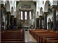
The interior of Holy Cross Church, Crumlin Road
The present Holy Cross church dates from 1903. This replaced an earlier church built in 1868. The parish has always been in the care of the Passionist order founded Paolo Danei in 1720.
Image: © Eric Jones
Taken: 21 Jul 2014
0.08 miles
8
Camp Twaddell from the top of Woodvale Road
Camp Twaddell was set up in response to the 2013 decision of the Northern Ireland Parades Commission that the 12th of July Orange Parades could march past the Ardoyne shop fronts in the Catholic Ardoyne Ward on their way into the city centre in the morning, but could as was traditional not march along an 800m section of the road past the shops on their return in the evening. The marchers claim that they have not been able to return home and set up a permanent protest camp - Camp Twaddell in Twaddell Avenue close to the Ardoyne roundabout.
Image: © Eric Jones
Taken: 21 Jul 2014
0.08 miles
9
Camp Twaddell at the junction of Twaddell Avenue and Crumlin Road
Camp Twaddell was set up in response to the 2013 decision of the Northern Ireland Parades Commission that the 12th of July Orange Parades could march past the Ardoyne shop fronts in the Catholic Ardoyne Ward on their way into the city centre in the morning, but could not march along an 800m section of the road past the shops on their return in the evening. The marchers claim that they have not been able to return home and set up a permanent protest camp - Camp Twaddell in Twaddell Avenue at the roundabout. A police presence has been maintained throughout to help preserve the peace at a cost of some £300,000 a week.
https://www.youtube.com/watch?v=nkSFAJWZVIw
Image: © Eric Jones
Taken: 21 Jul 2014
0.09 miles
10
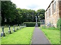
Passionists' burial plot at Holy Cross Church, Ardoyne
These are the only burials in the graveyard.
Image: © Eric Jones
Taken: 21 Jul 2014
0.09 miles