IMAGES TAKEN NEAR TO
Malcolmson Street, BELFAST, BT13 2RG
Introduction
This page details the photographs taken nearby to Malcolmson Street, BT13 2RG by members of the Geograph project.
The Geograph project started in 2005 with the aim of publishing, organising and preserving representative images for every square kilometre of Great Britain, Ireland and the Isle of Man.

There are currently over 7.5m images from over14,400 individuals and you can help contribute to the project by visiting https://www.geograph.org.uk
Image Map
Images are licensed for reuse under creativecommons.org/licenses/by-sa/2.0
Notes
- Clicking on the map will re-center to the selected point.
- The higher the marker number, the further away the image location is from the centre of the postcode.
Image Listing (44 Images Found)
Images are licensed for reuse under creativecommons.org/licenses/by-sa/2.0
Image
Details
Distance
1
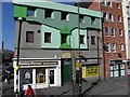
Ancient Order of the Hibernians Club, Belfast
The plaque above the doorway reads AOH Club and Lecture Hall; it is located along the Falls Road
Image: © Kenneth Allen
Taken: 8 Mar 2010
0.05 miles
2
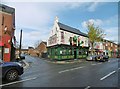
Belfast, McCartan's Fort Bar
Public house on Springfield Road, dating from 1865. Internally, many original features are retained: counter, left, with inlaid panels of majolica and hand painted landscape tiles; back bar with spirit barrels; tessellated floor; cast iron pillars; right and back, numbered booths (1 - 7) with doors, fully closing. A welcoming pub, popular with horse racing fans. TV; no cask ales.
Image: © Mike Faherty
Taken: 23 Apr 2018
0.05 miles
4
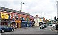
A row of small shops on the Falls Road
This image is taken from the corner of Grosvenor Road.
Image: © Eric Jones
Taken: 27 Apr 2012
0.07 miles
5
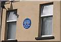
Blue Plaque in Cavendish Street
In honour of a former occupier Cathal O Byrne http://en.wikipedia.org/wiki/Cathal_O'Byrne
Image: © Paul McIlroy
Taken: 8 Apr 2009
0.07 miles
6
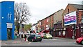
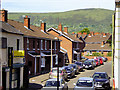
The lower end of Springfield Road viewed from the Falls Road
Like The Falls, the Springfield area is strongly nationalist and republican. It borders on to the equally staunch Protestant and Loyalist area of the Shankill.
http://en.wikipedia.org/wiki/Springfield_Road,_Belfast
Image: © Eric Jones
Taken: 27 Apr 2012
0.07 miles
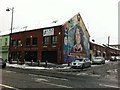
7
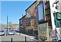
Belfast, mural 1)
On the corner of McQuillan Street and Falls Road; dedicated to freedom fighters.
Image: © Mike Faherty
Taken: 21 Apr 2018
0.08 miles
8
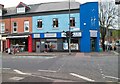
Falls Pharmacy and Falls Family Doctors Surgery on the Falls Road
This block stands on the corner of the Falls and Springfield roads.
Image: © Eric Jones
Taken: 27 Apr 2012
0.08 miles
10
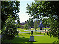
Dunville Park, West Belfast
Situated on the Falls Road, about a mile from the city centre, Dunville Park given to the city in 1889 by Robert G Dunville. It was opened as a public park in 1891.
A commemorative statue of local boxer, John Caldwell https://en.wikipedia.org/wiki/John_Caldwell_(boxer) , can be seen in the park centre foreground in the picture). John was a west Belfast man who represented Ireland at the 1956 Olympics in Melbourne and became World Bantamweight Champion in 1961.
Image: © David Dixon
Taken: 26 May 2017
0.09 miles