IMAGES TAKEN NEAR TO
Louden Street, Belfast Industrial Complex, BELFAST, BT13 2EZ
Introduction
This page details the photographs taken nearby to Louden Street, Belfast Industrial Complex, BT13 2EZ by members of the Geograph project.
The Geograph project started in 2005 with the aim of publishing, organising and preserving representative images for every square kilometre of Great Britain, Ireland and the Isle of Man.

There are currently over 7.5m images from over14,400 individuals and you can help contribute to the project by visiting https://www.geograph.org.uk
Image Map
Images are licensed for reuse under creativecommons.org/licenses/by-sa/2.0
Notes
- Clicking on the map will re-center to the selected point.
- The higher the marker number, the further away the image location is from the centre of the postcode.
Image Listing (166 Images Found)
Images are licensed for reuse under creativecommons.org/licenses/by-sa/2.0
Image
Details
Distance
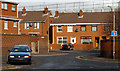
1
Boundary Street, Belfast
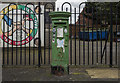
Built around 170 years ago when it would have been where the town of Belfast gave way to the countryside. This was an area affected by The Troubles. Points of reference include (left) Greenland Street Image, (middle background) the peace line and (upper right) Divis Tower Image
Image: © Albert Bridge
Taken: 19 Feb 2010
0.05 miles
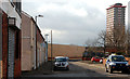
2
Fingal's Court and Finn Square, Belfast
Redeveloped streets off Divis Street. Built on the site of the mid-19th century Campbell’s Row. Finn Square is on the left.
Image: © Albert Bridge
Taken: 19 Feb 2010
0.05 miles
3
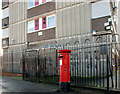
Pillar box, Belfast
EIIR pillar box, outside Divis Tower Image
Image: © Albert Bridge
Taken: 10 Feb 2011
0.10 miles
4
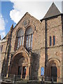
Doorway, Townsend Street Presbyterian church, Belfast
Townsend Street Presbyterian church was built in 1876-78 to a design by Young and Mackenzie. It has three ornate doorways of which this (the middle) is probably the most ornate. See also Image
Image: © Albert Bridge
Taken: 10 Dec 2009
0.10 miles
5

Wildflowers, Belfast
Wildflowers planted at Divis Street beside Townsend Street (there are more on the other side of Divis Street) – a joint venture between the Housing Executive and a local school.
Image: © Albert Bridge
Taken: 18 Jun 2010
0.11 miles
6
Pillar box, Belfast
Elizabeth II postbox (BT12 15D) on Divis Street in Belfast. Painted green (unofficially) to make it look similar to Image
Image: © Rossographer
Taken: 10 Sep 2019
0.11 miles
7
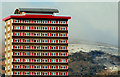
Divis Tower, Belfast
The upper floors of Divis Tower Image with low cloud and snow on the hills in the background. Continue to Image
Image: © Albert Bridge
Taken: 31 Jan 2010
0.11 miles
8
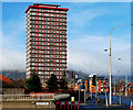
Divis Tower, Belfast (2)
See Image and Image The building, in its setting alongside Divis Street, with the Westlink Image (partly in an underpass) running along the bottom.
Image: © Albert Bridge
Taken: 19 Feb 2010
0.11 miles
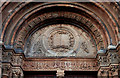
10
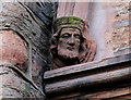
Head, Townsend Street Presbyterian church, Belfast (2)
See Image One of the heads on a doorway.
Image: © Albert Bridge
Taken: 19 Feb 2010
0.11 miles