IMAGES TAKEN NEAR TO
Dover Street, BELFAST, BT13 2EB
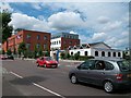
Introduction
This page details the photographs taken nearby to Dover Street, BT13 2EB by members of the Geograph project.
The Geograph project started in 2005 with the aim of publishing, organising and preserving representative images for every square kilometre of Great Britain, Ireland and the Isle of Man.

There are currently over 7.5m images from over14,400 individuals and you can help contribute to the project by visiting https://www.geograph.org.uk
Image Map
Images are licensed for reuse under creativecommons.org/licenses/by-sa/2.0
Notes
- Clicking on the map will re-center to the selected point.
- The higher the marker number, the further away the image location is from the centre of the postcode.
Image Listing (144 Images Found)
Images are licensed for reuse under creativecommons.org/licenses/by-sa/2.0
Image
Details
Distance
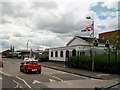
1
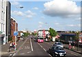
Re-developed lower section of the Shankill
In 2009, when the Google Streetview cameras visited the area, the land on the left side of the road was a demolition site.
Image: © Eric Jones
Taken: 19 May 2012
0.06 miles
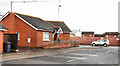
2
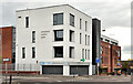
The Cornerstone Medical Centre, Belfast
A health centre, at the corner of the Shankill Road (foreground) and Shankill Parade, opened in early 2011.
Image: © Albert Bridge
Taken: 6 May 2012
0.07 miles
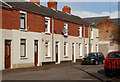
3
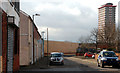
Boundary Street, Belfast
Built around 170 years ago when it would have been where the town of Belfast gave way to the countryside. This was an area affected by The Troubles. Points of reference include (left) Greenland Street Image, (middle background) the peace line and (upper right) Divis Tower Image
Image: © Albert Bridge
Taken: 19 Feb 2010
0.07 miles
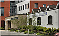
4
The Shankill's new Cornerstone Medical Centre
The centre, opened in 2011, houses three doctor's surgeries and a large pharmacy,
http://greatershankillpartnership.org/news-blogs/news-articles/88-new-medical-centre-opens.html
Image: © Eric Jones
Taken: 19 May 2012
0.08 miles
5
Shankill Parade at its junction with Shankill Road
The white building on the right is the Shankill Gospel Hall.
Image: © Eric Jones
Taken: 21 Jul 2014
0.08 miles
6
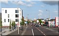
Dover Street, Belfast
Built in the mid 19th century, Dover Street ran from Divis Street to the Shankill. Redevelopment, taking into consideration the effects of “The Troubles” or the “Armed Struggle” depending on your particular viewpoint, in the two areas, saw it truncated with Louden Street Industrial Estate built in between. This is today’s street as it meets the Shankill Road. As a sign of return to normality it now boasts a “KFC”.
Image: © Albert Bridge
Taken: 26 Mar 2010
0.08 miles
7
Shankill gospel hall, Belfast
Modern gospel hall, facing the Shankill Road, at the corner of Shankill Parade.
Image: © Albert Bridge
Taken: 6 May 2012
0.08 miles
8
Greenland Street, Belfast
A street off the Shankill Road built about 1845/50. Only the western side remains.
Image: © Albert Bridge
Taken: 19 Feb 2010
0.09 miles
9
The Shankill Gospel Hall, Lower Shankill
The brick fronted building next to is the Shankill Wellbeing and Treatment Centre.
Image: © Eric Jones
Taken: 21 Jul 2014
0.09 miles
10
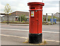
Victorian pillar box, Belfast
VR pillar box (BT13 302) outside the Wellbeing Centre, on the Shankill Road, near Shankill Parade.
Image: © Albert Bridge
Taken: 6 May 2012
0.10 miles