IMAGES TAKEN NEAR TO
Conway Walk, BELFAST, BT13 2DY
Introduction
This page details the photographs taken nearby to Conway Walk, BT13 2DY by members of the Geograph project.
The Geograph project started in 2005 with the aim of publishing, organising and preserving representative images for every square kilometre of Great Britain, Ireland and the Isle of Man.

There are currently over 7.5m images from over14,400 individuals and you can help contribute to the project by visiting https://www.geograph.org.uk
Image Map
Images are licensed for reuse under creativecommons.org/licenses/by-sa/2.0
Notes
- Clicking on the map will re-center to the selected point.
- The higher the marker number, the further away the image location is from the centre of the postcode.
Image Listing (160 Images Found)
Images are licensed for reuse under creativecommons.org/licenses/by-sa/2.0
Image
Details
Distance
1
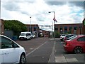
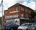
The Argyle Street Business Centre off the Shankill Road
Image: © Eric Jones
Taken: 21 Jul 2014
0.06 miles
2
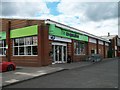
Co-op Food Store in Spier's Place, Shankill Road
Image: © Eric Jones
Taken: 21 Jul 2014
0.07 miles
3
The Shankill Protestant Boys Flute Band Mural
This mural occupies a wall at the corner of Northumberland Street and Shankill Road.
http://www.youtube.com/watch?v=Of1JQdBnS_4
Image: © Eric Jones
Taken: 21 Jul 2014
0.07 miles
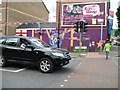
4
UVF Memorial and 1913 Gun Running murals in Spier's Place
The gun running mural depicts an UVF roadblock in the fishing village of Donagadee, one of the places through which guns were shipped from Germany in 1913.
http://en.wikipedia.org/wiki/Larne_gun-running
Image: © Eric Jones
Taken: 21 Jul 2014
0.08 miles
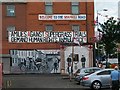
5
"Welcome to the Shankill Road"
The welcome banner adorns the Spier's Place gable end of a block of small shops. The second banner has been put up by FAST a human rights group opposed to what they see as the injustice of trials of paramilitaries where the sole or main evidence comes from men granted immunity for having turned Queen's Evidence. The lower half of the wall has two murals - an UVF memorial and ‘preparing to bare arms’ scene recalling the gun running episodes of 1913.
http://www.fast-ni.co.uk/history.html
Image]
Image: © Eric Jones
Taken: 21 Jul 2014
0.08 miles
6
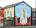
"Ulster Tower" mural, Belfast
A mural, at the Shankill Road end of Conway Street, depicting The Ulster Tower http://en.wikipedia.org/wiki/Ulster_Tower at Thiepval. The tower is modelled on Helen’s Tower at Clandeboye http://www.geograph.org.uk/snippet/3360 and is a memorial to those members of the 36th (Ulster) Division of His Majesty’s army killed in World War 1. It replaced this one Image (August 2009).
Image: © Albert Bridge
Taken: 6 Oct 2013
0.09 miles
7
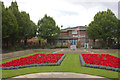
Memorial gardens, Shankill Road, Belfast
The memorial is to the Ulster soldiers who died in the two World Wars, particularly the Battle of the Somme.
Image: © Robert Eva
Taken: 5 Aug 2017
0.09 miles
9
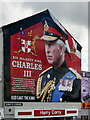
King's Corner
Loyalist mural of King Charles on the gable end of a shop on the corner of Argyle Street and Shankill Road.
Image: © David Dixon
Taken: 16 Aug 2023
0.09 miles
10

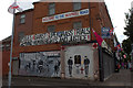
Murals, West Belfast (10)
It is located at the junction of Conway Street and the Shankill Road
Image: © Kenneth Allen
Taken: 8 Mar 2010
0.09 miles