IMAGES TAKEN NEAR TO
Crossland Court, BELFAST, BT13 2DT
Introduction
This page details the photographs taken nearby to Crossland Court, BT13 2DT by members of the Geograph project.
The Geograph project started in 2005 with the aim of publishing, organising and preserving representative images for every square kilometre of Great Britain, Ireland and the Isle of Man.

There are currently over 7.5m images from over14,400 individuals and you can help contribute to the project by visiting https://www.geograph.org.uk
Image Map
Images are licensed for reuse under creativecommons.org/licenses/by-sa/2.0
Notes
- Clicking on the map will re-center to the selected point.
- The higher the marker number, the further away the image location is from the centre of the postcode.
Image Listing (166 Images Found)
Images are licensed for reuse under creativecommons.org/licenses/by-sa/2.0
Image
Details
Distance
1
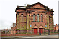
Nelson Memorial Presbyterian church, Belfast
The Nelson Memorial Presbyterian church, Annesboro Street, completed in 1887 to a design by William J Gilliland. The church is named after the Rev Isaac Nelson http://en.wikipedia.org/wiki/Isaac_Nelson a United Irishman who was born at “Sugarfield” a house in what was to become Bellevue Street. His grave is in Shankill Graveyard http://www.belfastcity.gov.uk/community/cemeteries/shankillgraveyard.aspx.
To put matters in a geographical context, the photograph was taken from Sugarfield Street. Bellevue Street is next right (out of picture).
Image: © Albert Bridge
Taken: 7 Apr 2014
0.09 miles
2
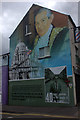
Hugh Smyth memorial mural, Shankill, Belfast
On the corner of Canmore Street and Shankill Road
Image: © Robert Eva
Taken: 5 Aug 2017
0.11 miles
3
Murals on the Alpha Taxis building on Shankill Road
Image: © Eric Jones
Taken: 19 May 2012
0.12 miles
4
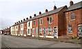
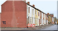
Lawnbrook Avenue, Belfast - April 2014(1)
Part of the western/south western side of Lawnbrook Avenue, close to the redeveloped area. One of the points about today’s houses is that they are noticeably lower than their Victorian counterparts.
Image: © Albert Bridge
Taken: 7 Apr 2014
0.12 miles
5
Lawnbrook Avenue, Belfast - December 2014(3)
The back of these derelict houses Image, on the western side of Lawnbrook Avenue, seen from Azamor Street. The now-demolished Glenwood Street is out of picture to the left.
Image: © Albert Bridge
Taken: 16 Dec 2014
0.12 miles
6
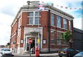
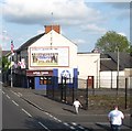
The Shankill Public Library
Built in the 1920s, the Shankill Road Public Library stands at the corner of Shankill Road and Mountjoy Road.
Image: © Eric Jones
Taken: 21 Jul 2014
0.12 miles
7
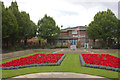
Memorial gardens, Shankill Road, Belfast
The memorial is to the Ulster soldiers who died in the two World Wars, particularly the Battle of the Somme.
Image: © Robert Eva
Taken: 5 Aug 2017
0.12 miles
8
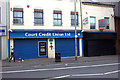
Court Credit Union, Shankill Road, Belfast
This is on the site of Frizell's Fish Shop which was the target of one of the most notorious bombing incidents during the troubles. The red cross can be seen on several buildings in the area and signifies the site of an incident during the troubles.
Image: © Robert Eva
Taken: 5 Aug 2017
0.13 miles
9
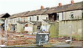
Lawnbrook Avenue, Belfast - December 2014(2)
Houses on the western side still standing and derelict. Demolition of the neighbouring Glenwood Street, now completed, started during September 2014. For future reference Azamor Street is on the left. Image shows the back view
Image: © Albert Bridge
Taken: 16 Dec 2014
0.13 miles
10
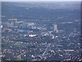
Shankill Road and the Odyssey
A view from Black Mountain with the Shankill Road prominent in the foreground and the Odyssey Arena in the middle.
Image: © Peter Robinson
Taken: 19 Oct 2011
0.13 miles