1
Conway Mill, Belfast
Interior shot of Conway Mill. The roof looks like a new addition added when the structure was refurbished.
Image: © Rossographer
Taken: 19 Aug 2012
0.01 miles
2
Yarn tester, Conway Mill, Belfast
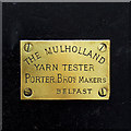
Plaque on an antique "Mulholland Yarn Tester" now preserved and displayed on a wall at Conway Mill
Image It was made by Porter Brothers in Belfast.
Image: © Rossographer
Taken: 19 Aug 2012
0.01 miles
3
Yarn tester, Conway Mill, Belfast
Antique "Mulholland Yarn Tester" now preserved and displayed on a wall at Conway Mill. It was made by Porter Brothers in Belfast. See
Image for the maker's plaque.
Image: © Rossographer
Taken: 19 Aug 2012
0.01 miles
4
Conway Mill, Belfast
Interior shot of Conway Mill. There are a variety of retail units through the doors on the ground floor.
Image: © Rossographer
Taken: 19 Aug 2012
0.01 miles
5
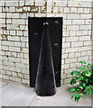
Corner Protector, Conway Mill, Belfast
Cast iron corner protector on a wall at Conway Mill. One of at least three I spotted, it has no visible foundry mark.
Image: © Rossographer
Taken: 19 Aug 2012
0.02 miles
6
There's more in common than what divides us...
On Cupar Way
Image: © Darrin Antrobus
Taken: 22 Mar 2013
0.05 miles
7
Belfast, Peace Wall
Part of the 800m long wall separating the Republican and Unionist communities in West Belfast. Seen from the Republican side. https://www.theguardian.com/cities/2015/sep/29/belfast-berlin-wall-moment-permanent-peace-walls
Image: © Mike Faherty
Taken: 21 Apr 2018
0.06 miles
8
Belfast - "Peace Line" Wall - Icons at Top of Wall off Howard Street
Image: © Suzanne Mischyshyn
Taken: 23 Sep 2013
0.07 miles
9
Mural, Belfast
Mural of Christ on the peace line at the corner of Cupar Way and North Howard Street in Belfast. Artist unknown.
The date 1897 is above the mural - from what I can tell from old OS maps, this was the site of the former Falls Foundry (later to become Combe, Barbour & Combe https://www.gracesguide.co.uk/Combe,_Barbour_and_Combe ).
Image: © Rossographer
Taken: 14 Jan 2023
0.07 miles
10
Belfast trolleybuses on Falls Road - 1968
A slow moving funeral cortege on its way to the City Cemetery has caused real problems for the bus service, with 7 vehicles now all bunched together. This must have been a regular headache for the City Transport department in attempting to maintain scheduled services. The view was taken during the last weeks of operation of trolleybuses in Belfast.
This section of Falls Road has changed beyond recognition, and indeed the only building visible here which still remains is the distant Divis Tower. On the right new housing has been developed, and on the left the industrial buildings have been replaced by a leisure centre and the Twin Spires complex.
This is one of a series of views featuring buses in the 60s, 70s, and 80s. http://www.geograph.org.uk/search.php?i=137652761
Image: © Alan Murray-Rust
Taken: 14 Apr 1968
0.07 miles


