IMAGES TAKEN NEAR TO
Sydney Street West, BELFAST, BT13 1RP
Introduction
This page details the photographs taken nearby to Sydney Street West, BT13 1RP by members of the Geograph project.
The Geograph project started in 2005 with the aim of publishing, organising and preserving representative images for every square kilometre of Great Britain, Ireland and the Isle of Man.

There are currently over 7.5m images from over14,400 individuals and you can help contribute to the project by visiting https://www.geograph.org.uk
Image Map
Images are licensed for reuse under creativecommons.org/licenses/by-sa/2.0
Notes
- Clicking on the map will re-center to the selected point.
- The higher the marker number, the further away the image location is from the centre of the postcode.
Image Listing (69 Images Found)
Images are licensed for reuse under creativecommons.org/licenses/by-sa/2.0
Image
Details
Distance
1
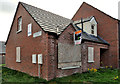
Vacant house, Belfast (2)
Vacant and boarded–up house at the corner of Baden Powell Street (left) and Silvio Street. Not a development site, it has an “agreed” sign.
Image: © Albert Bridge
Taken: 13 Sep 2011
0.09 miles
2
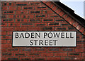
Baden Powell Street sign, Belfast
Modern sign at the Silvio Street end of Baden Powell Street. Now redeveloped, work on the original street seems to have started in 1901. This link refers to the gentleman after whom it is named http://en.wikipedia.org/wiki/Baden_Powell.
Image: © Albert Bridge
Taken: 13 Sep 2011
0.09 miles
3
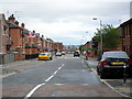
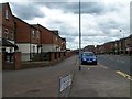
Ambleside Street, Belfast
Off Tennent Street. Whoever named the streets around here must just have returned from their holidays in the Lake District - as Keswick Street and Coniston Street (now redeveloped and renamed Coniston Close) are just around the corner.
Image: © Dean Molyneaux
Taken: 26 Aug 2009
0.10 miles
5
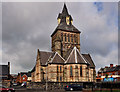
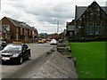
St Mary's Church of Ireland, Belfast
St Mary’s Church of Ireland, at the corner of Silvio Street (foreground) and the Crumlin Road. Completed in 1868 to a design by the London architect William Slater. Damaged by the Luftwaffe in 1941, the church needed substantial repairs which were done, in 1945, by Dennis O’D Hanna who (later) designed Image
Image: © Albert Bridge
Taken: 13 Sep 2011
0.10 miles
7
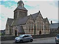
St Mary's Parish Church CoI, Crumlin Road
Built in the 1860s of sandstone and Mourne granite, St Mary's was designed in the gothic style with an enormous central tower and at a cost £6,500. The parish served an area dependent on the linen industry and suffered a decline when that industry collapsed in the 1960s. One of St Mary's more unusual parishioners was John Graham, Belfast Commander and Northern Director of Intelligence of the IRA in the 1940s. A staunch Protestant he successfully fought against the placing of a picture of the Virgin Mary in the church.
http://www.politics.ie/forum/history/194860-john-graham-protestant-ira-belfast-brigade-commander.html
Image: © Eric Jones
Taken: 21 Jul 2014
0.12 miles
8
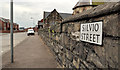
Silvio Street sign, Belfast
The sign at the Crumlin Road end of Silvio Street. Now redeveloped, building of the original street started around 1870 when it had seven houses.
Image: © Albert Bridge
Taken: 1 Sep 2011
0.12 miles
9
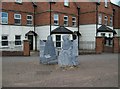
Millgirl statues on the corner of Snugville Street and Crumlin Road
Carved on the base of the second statue are names of the three huge mills which operated on this stretch of Crumlin Road - Ewarts, Edenderry and Brookfield.
Image: © Eric Jones
Taken: 21 Jul 2014
0.14 miles
10
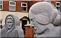
Millworkers sculpture, Belfast (2)
See Image A close look at the two figures. The one on the left is wearing a shawl – something which, while by then relatively rare, nevertheless continued into the late 1960’s.
Image: © Albert Bridge
Taken: 13 Sep 2011
0.14 miles