IMAGES TAKEN NEAR TO
Shankill Road, BELFAST, BT13 1FR
Introduction
This page details the photographs taken nearby to Shankill Road, BT13 1FR by members of the Geograph project.
The Geograph project started in 2005 with the aim of publishing, organising and preserving representative images for every square kilometre of Great Britain, Ireland and the Isle of Man.

There are currently over 7.5m images from over14,400 individuals and you can help contribute to the project by visiting https://www.geograph.org.uk
Image Map
Images are licensed for reuse under creativecommons.org/licenses/by-sa/2.0
Notes
- Clicking on the map will re-center to the selected point.
- The higher the marker number, the further away the image location is from the centre of the postcode.
Image Listing (152 Images Found)
Images are licensed for reuse under creativecommons.org/licenses/by-sa/2.0
Image
Details
Distance
1

Mrs Agnes Brown, Rory and Grandad on the Shankill
Mrs Brown and her Boys happily transcend political and sectarian boundaries.
http://en.wikipedia.org/wiki/Mrs._Brown's_Boys
Image: © Eric Jones
Taken: 21 Jul 2014
0.01 miles
2
The Royal Bar on the corner of Snugville Street and Shankill Road
Image: © Eric Jones
Taken: 21 Jul 2014
0.02 miles
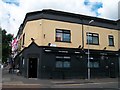
3
Bar Berlin, Shankill Road, Belfast
One of the six remaining pubs along the Shankill Road.
Image: © Robert Eva
Taken: 5 Aug 2017
0.02 miles
4
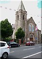
The West Kirk Presbyterian Church, Shankill Road
This is the former Argyle Street church, renamed when the congregation merged with that of Albert Street at the height of The Troubles.
Image: © Eric Jones
Taken: 21 Jul 2014
0.02 miles
5
Memorial lamp, Shankill Road
Close to the Hugh Smyth centre and the war memorial, this lamp is always lit as a memorial to those killed in the troubles.
Image: © Robert Eva
Taken: 5 Aug 2017
0.03 miles
6
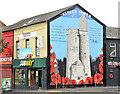
"Ulster Tower" mural, Belfast
A mural, at the Shankill Road end of Conway Street, depicting The Ulster Tower http://en.wikipedia.org/wiki/Ulster_Tower at Thiepval. The tower is modelled on Helen’s Tower at Clandeboye http://www.geograph.org.uk/snippet/3360 and is a memorial to those members of the 36th (Ulster) Division of His Majesty’s army killed in World War 1. It replaced this one Image (August 2009).
Image: © Albert Bridge
Taken: 6 Oct 2013
0.03 miles
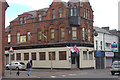
7

Shankill Radio, Belfast
Also included are Shankill Dental Centre, Job Assist Centre and Community Development & Transition Group
Image: © Kenneth Allen
Taken: 8 Mar 2010
0.03 miles
8
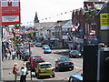
Shankill Road in Belfast
This photo was taken in July 2006 from the top of an open top tour bus.
Image: © Puffer
Taken: 14 Jul 2006
0.03 miles
9
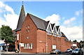
Shankill Road Methodist Church, Belfast (August 2018)
Shankill Road Methodist church, at the corner of Berlin Street (right). Date of building unknown (further information welcome). Some information from old street directories: No 267 - 1890 WJ Allen, smithworks, 1901 vacant ground, 1907 Shankill Road Primitive Methodist church.
Image: © Albert Bridge
Taken: 16 Aug 2018
0.04 miles
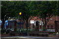
10
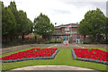
Memorial gardens, Shankill Road, Belfast
The memorial is to the Ulster soldiers who died in the two World Wars, particularly the Battle of the Somme.
Image: © Robert Eva
Taken: 5 Aug 2017
0.04 miles