IMAGES TAKEN NEAR TO
Sherbrook Terrace, BELFAST, BT13 1ET
Introduction
This page details the photographs taken nearby to Sherbrook Terrace, BT13 1ET by members of the Geograph project.
The Geograph project started in 2005 with the aim of publishing, organising and preserving representative images for every square kilometre of Great Britain, Ireland and the Isle of Man.

There are currently over 7.5m images from over14,400 individuals and you can help contribute to the project by visiting https://www.geograph.org.uk
Image Map
Images are licensed for reuse under creativecommons.org/licenses/by-sa/2.0
Notes
- Clicking on the map will re-center to the selected point.
- The higher the marker number, the further away the image location is from the centre of the postcode.
Image Listing (228 Images Found)
Images are licensed for reuse under creativecommons.org/licenses/by-sa/2.0
Image
Details
Distance
1
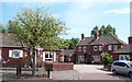
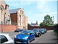
Houses on the east side of Denmark Street
Image: © Eric Jones
Taken: 10 Jul 2015
0.03 miles
2
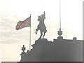
Belfast: Clifton Street Orange Hall (rooftop detail)
A close-up of the roof of Image, looking into the morning sun. Coils of barbed wire can be discerned right of picture.
Image: © Chris Downer
Taken: 12 Nov 2007
0.03 miles
3
The northern end of Denmark Street in the Lower Shankill
Image: © Eric Jones
Taken: 10 Jul 2015
0.04 miles
4
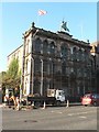
Belfast: Clifton Street Orange Hall
This building, at 82-84 Clifton Street, is in something of a sorry state. It is dated 1690 below the horse, though some Internet investigations suggest that it was built around 1860.
See also Image
Image: © Chris Downer
Taken: 12 Nov 2007
0.04 miles
5
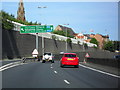
Westlink at Clifton Street
The A12 Westlink (Belfast's principal throughpass) here passes Clifton Street. Leaving here is recommended for the lower Antrim Road, Carlisle Circus and the Crumlin Road.
Image: © Dean Molyneaux
Taken: 12 Sep 2009
0.05 miles
6
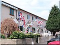
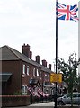
Twelfth of July bunting in Denmark Street
Denmark Street is close to the interface between the Loyalist Lower Shankill and the Nationalist New Lodge areas.
Image: © Eric Jones
Taken: 10 Jul 2015
0.05 miles
7
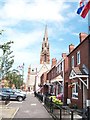
The north eastern end of Denmark Street
The north end of Denmark Street opens on to Carlisle Circus. The steeple is that of the former Carlisle Memorial Methodist Church.
Image: © Eric Jones
Taken: 10 Jul 2015
0.06 miles
8
The rear of the Clifton Street Orange Hall
The rear of the building is in what used to be the northern end of Regent Street. The building of the Westlink urban motorway made this section of road a cul-de-sac.
Image: © Eric Jones
Taken: 10 Jul 2015
0.06 miles
9
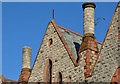
Former Carlisle Memorial church, Belfast (6)
Part of the back of the building seen from Regent Street. The two cylindrical structures are (I think) chimneys.
Image: © Albert Bridge
Taken: 24 Oct 2013
0.06 miles
10
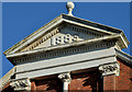
Clifton Street Orange Hall, Belfast (1)
A spherical finial topping a pediment enclosing the date of completion (1883), at the back of the building (Regent Street).
Image: © Albert Bridge
Taken: 24 Oct 2013
0.07 miles