IMAGES TAKEN NEAR TO
Agnes Close, BELFAST, BT13 1DJ
Introduction
This page details the photographs taken nearby to Agnes Close, BT13 1DJ by members of the Geograph project.
The Geograph project started in 2005 with the aim of publishing, organising and preserving representative images for every square kilometre of Great Britain, Ireland and the Isle of Man.

There are currently over 7.5m images from over14,400 individuals and you can help contribute to the project by visiting https://www.geograph.org.uk
Image Map
Images are licensed for reuse under creativecommons.org/licenses/by-sa/2.0
Notes
- Clicking on the map will re-center to the selected point.
- The higher the marker number, the further away the image location is from the centre of the postcode.
Image Listing (140 Images Found)
Images are licensed for reuse under creativecommons.org/licenses/by-sa/2.0
Image
Details
Distance
1
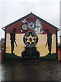
Colourful fence
This brightly coloured fence is at Crumlin Road Health Centre.
Image: © Paul McIlroy
Taken: 6 Mar 2008
0.09 miles
2
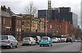
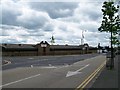
The Crumlin Road (3)
This picture shows two well known buildings on the Crumlin Road, the first one is the Crumlin Road Jail (no longer in use) and next to that is the Mater Hospital.
Image: © Paul McIlroy
Taken: 6 Mar 2008
0.09 miles
3
Immanuel Presbyterian church, Belfast (September 2014)
A Presbyterian church, on the western side of Agnes Street. The church’s website http://www.immanuelbelfast.co.uk/ states “The congregation was born in 1971 out of a union of Agnes Street and Bethany congregations and a further union took place in 2007 when Immanuel and Oldpark congregations amalgamated. Due to structural problems with the old church building a new meeting house was constructed on the same site. It opened on the 9th February 2008”. Not to be confused with this one Image
Image: © Albert Bridge
Taken: 10 Sep 2014
0.09 miles
5
Car Tints NI on Agnes Street Industrial Estate
This firm specialises in tinting car windows.
Image: © Eric Jones
Taken: 21 Jul 2014
0.10 miles
6
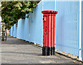
Pillar box BT13 140, Belfast
EIIR pillar box (BT13 140) at Agnes Street, close to the Hammer Youth Club.
Image: © Albert Bridge
Taken: 10 Sep 2014
0.10 miles
7
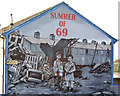
"Summer of 69" mural, Belfast
A mural, at Hopewell Crescent off the Crumlin Road depicting the devastation of the summer (and particularly August) in 1969. The early days of “The Troubles” (a term borrowed from an earlier conflict) saw a mass movement of people and destruction of homes. The sight of furniture dumped in the street and the word “taken” painted on an empty house next to a burned-out one is not to be forgotten. Rumours of the dead being carried away through the sewers. Ach sure the tourists love it all when they see it from their open-top buses but they weren’t there and many weren't even born.
Image: © Albert Bridge
Taken: 24 Oct 2013
0.11 miles
8
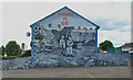
The "Summer of 69" mural in Hopewell Crescent
This Loyalist mural commemorates the sectarian riots of 1969 when families in mixed communities were burnt out of their homes by their neighbours on religious grounds. This "ethnic cleansing" led to the increased ghettoization of both Protestant and Catholic working classes.
Image: © Eric Jones
Taken: 21 Jul 2014
0.11 miles
9
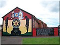
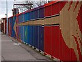
The Red Hand Commando mural on the Hopewell Estate
This Loyalist mural in Hopewell Avenue dates from the year 2000. It commemorates one of its leading members, Stevie McCrea, killed by the Irish People's Liberation Organisation in 1989. The RHC was an off-shoot of the UVF.
http://en.wikipedia.org/wiki/Red_Hand_Commando
Image: © Eric Jones
Taken: 21 Jul 2014
0.11 miles