IMAGES TAKEN NEAR TO
North Boundary Street, BELFAST, BT13 1DH
Introduction
This page details the photographs taken nearby to North Boundary Street, BT13 1DH by members of the Geograph project.
The Geograph project started in 2005 with the aim of publishing, organising and preserving representative images for every square kilometre of Great Britain, Ireland and the Isle of Man.

There are currently over 7.5m images from over14,400 individuals and you can help contribute to the project by visiting https://www.geograph.org.uk
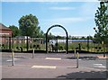
Image Map
Images are licensed for reuse under creativecommons.org/licenses/by-sa/2.0
Notes
- Clicking on the map will re-center to the selected point.
- The higher the marker number, the further away the image location is from the centre of the postcode.
Image Listing (150 Images Found)
Images are licensed for reuse under creativecommons.org/licenses/by-sa/2.0
Image
Details
Distance
1
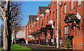
Shankill Terrace, Belfast (2)
See Image Part of the same terrace – this end faces Peter’s Hill.
Image: © Albert Bridge
Taken: 10 Feb 2011
0.03 miles
2
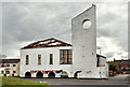
Derelict church, Belfast
A derelict church at North Boundary Street, opposite Boundary Walk. It was (I think) previously the Assemblies of God Pentecostal Church which now has another church nearby. If I am wrong please let me know.
Image: © Albert Bridge
Taken: 6 May 2012
0.04 miles
3
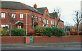
Shankill Terrace, Belfast
Part of a redeveloped area at (not shown on the Google map) on the lower Shankill. See also Image
Image: © Albert Bridge
Taken: 13 Dec 2009
0.06 miles
4
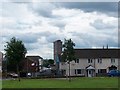
The Nationalist Divis Tower towering above the low rise housing estates of the Loyalist Lower Shankill
The Divis Tower built in 1963 pre-dates the modern low rise estates off both the Shankill and the Falls Roads.
Image
Image: © Eric Jones
Taken: 21 Jul 2014
0.06 miles
5

Warning to Drug Pedlars in the Lower Shankill
Image: © Eric Jones
Taken: 21 Jul 2014
0.07 miles
6
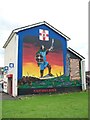
Cuchulainn Mural on the shop at Shankill Parade
Image: © Eric Jones
Taken: 21 Jul 2014
0.07 miles
7
Dover Street, Belfast
Built in the mid 19th century, Dover Street ran from Divis Street to the Shankill. Redevelopment, taking into consideration the effects of “The Troubles” or the “Armed Struggle” depending on your particular viewpoint, in the two areas, saw it truncated with Louden Street Industrial Estate built in between. This is today’s street as it meets the Shankill Road. As a sign of return to normality it now boasts a “KFC”.
Image: © Albert Bridge
Taken: 26 Mar 2010
0.08 miles
8
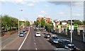
View east along the lower end of the Shankill Road
Image: © Eric Jones
Taken: 19 May 2012
0.08 miles
9
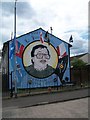
Mural depicting Lt Jackie Coulter, UDA, a victim of a Loyalist Feud
Jackie Coulter was shot dead by a gunman from a rival loyalist paramilitary organisation - the UVF - on the Crumlin Road, Belfast in August 2000. He was a resident of St Mary's Court off Silvio Street.
Image: © Eric Jones
Taken: 21 Jul 2014
0.08 miles
10
The Growing Garden in Denmark Street
This is a lower Shankill community development iniative whereby vacant land in Denmark Street near the interface fence has been converted into gardening space. The project includes the providion of an outdoor classroom, community growing strips and informal play areas.
http://www.newsletter.co.uk/news/regional/fruit-and-veg-to-replace-eyesore-1-5941019
Image: © Eric Jones
Taken: 10 Jul 2015
0.08 miles