IMAGES TAKEN NEAR TO
York Lane, BELFAST, BT1 2LY
Introduction
This page details the photographs taken nearby to York Lane, BT1 2LY by members of the Geograph project.
The Geograph project started in 2005 with the aim of publishing, organising and preserving representative images for every square kilometre of Great Britain, Ireland and the Isle of Man.

There are currently over 7.5m images from over14,400 individuals and you can help contribute to the project by visiting https://www.geograph.org.uk
Image Map
Images are licensed for reuse under creativecommons.org/licenses/by-sa/2.0
Notes
- Clicking on the map will re-center to the selected point.
- The higher the marker number, the further away the image location is from the centre of the postcode.
Image Listing (1818 Images Found)
Images are licensed for reuse under creativecommons.org/licenses/by-sa/2.0
Image
Details
Distance
1
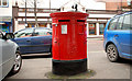
Pillar box, Belfast
Dual-aperture EIIR pillar box in Donegall Street near the “Irish News” Image
Image: © Albert Bridge
Taken: 28 Jan 2011
0.01 miles
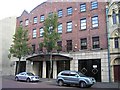
2
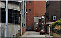
York Lane, Belfast (2)
York Lane seen from close to Carrick Hill and Frederick Street. The Interpoint car park Image is on the left. The development includes a proposal for “Public realm improvements to York Lane and in proximity to university buildings”.
Image: © Albert Bridge
Taken: 29 Apr 2012
0.01 miles
3
The "Interpoint" Building, Belfast #24
A remaining part of the “Interpoint”, at York Lane, seen from the corner of Donegall Lane.
Image: © Albert Bridge
Taken: 28 Aug 2013
0.01 miles
4
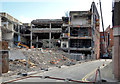
The "Interpoint" Building, Belfast #8
Demolition underway at the back of the Interpoint. Frederick Street is on the left.
Image: © Albert Bridge
Taken: 8 Aug 2013
0.01 miles
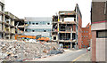
5
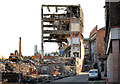
The "Interpoint" Building, Belfast (68)
The skeletal remains, at York Lane, seen from the corner of Donegall Lane.
Image: © Albert Bridge
Taken: 24 Oct 2013
0.01 miles
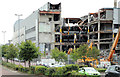
6
The "Interpoint" Building, Belfast (30)
Demolition continuing beside York Lane. Note the hose (bottom) used to spray water for dust suppression. See also Image
Image: © Albert Bridge
Taken: 6 Sep 2013
0.01 miles
7
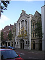
Donegall Street Congregational Church, Belfast
The original church on this site was completed in 1860, with additions in 1871 on either side. It was rebuilt in 1955 following extensive bomb damage during the Belfast Blitz of World War II. The wings to either side are older.
Image: © Kenneth Allen
Taken: 16 Oct 2009
0.01 miles
8

Former St Patrick's school, Belfast (6)
See Image A plaque showing the school’s later status.
Image: © Albert Bridge
Taken: 21 Jun 2009
0.01 miles
9
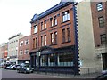
Irish News Ltd Building, Belfast
It is located at Donegall Street
Image: © Kenneth Allen
Taken: 16 Oct 2009
0.02 miles
10
Charles House, Belfast
It is located at Donegall Street
Image: © Kenneth Allen
Taken: 16 Oct 2009
0.02 miles