IMAGES TAKEN NEAR TO
Donegall Gardens, BELFAST, BT12 6NU
Introduction
This page details the photographs taken nearby to Donegall Gardens, BT12 6NU by members of the Geograph project.
The Geograph project started in 2005 with the aim of publishing, organising and preserving representative images for every square kilometre of Great Britain, Ireland and the Isle of Man.

There are currently over 7.5m images from over14,400 individuals and you can help contribute to the project by visiting https://www.geograph.org.uk
Image Map
Images are licensed for reuse under creativecommons.org/licenses/by-sa/2.0
Notes
- Clicking on the map will re-center to the selected point.
- The higher the marker number, the further away the image location is from the centre of the postcode.
Image Listing (267 Images Found)
Images are licensed for reuse under creativecommons.org/licenses/by-sa/2.0
Image
Details
Distance
1
Tate's Avenue, Belfast (3)
See Image The western end of Tate’s Avenue, looking towards the Lisburn Road, showing the original line (left) below the present line.
Image: © Albert Bridge
Taken: 4 Jul 2010
0.02 miles
2
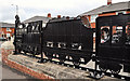
Train sculpture, Belfast (1)
A sculpture, on the northern side of the Tate’s Avenue bridge (Glenmachan Street end), depicting a train from the Victorian era. By David McClelland, it is part of the “Re-imaging Communities” project Image
Image: © Albert Bridge
Taken: 29 May 2011
0.02 miles
3
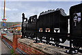
Train sculpture, Belfast (2)
See Image A similar one on the other (southern) side.
Image: © Albert Bridge
Taken: 29 May 2011
0.02 miles
4
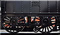
Train sculpture, Belfast (3)
A close look at the detail of the driving wheels of the 2-4-0 locomotive seen in Image
Image: © Albert Bridge
Taken: 29 May 2011
0.02 miles
5
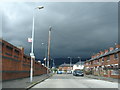
Tates Avenue Belfast
Thunder clouds on the way
Image: © Ronan Magee
Taken: 10 Jul 2008
0.02 miles
6
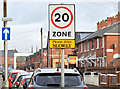
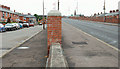
20 mph zone, Ebor Street, Belfast (December 2014)
A 20mph zone in that part of Ebor Street on the northern side of Tate’s Avenue. Narrow and densely populated.
Image: © Albert Bridge
Taken: 4 Dec 2014
0.03 miles
7
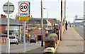
20 mph zone, Tate's Avenue, Belfast (December 2014)
A 20mph zone along part of Tate’s Avenue on the northern side of the bridge.
Image: © Albert Bridge
Taken: 4 Dec 2014
0.03 miles
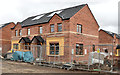
8
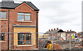
New houses, Frenchpark Street, Belfast (2013-2)
New apartments under construction, in Frenchpark Street, close the remains of Moltke Street and Broadway Parade (right).
Image: © Albert Bridge
Taken: 21 Apr 2013
0.04 miles
9
New houses, Frenchpark Street, Belfast (2013-1)
New apartments under construction at the corner of Frenchpark Street and Ebor Street (right).
Image: © Albert Bridge
Taken: 21 Apr 2013
0.05 miles
10

Phoenix Gas Christmas poster, Belfast (December 2014)
See Image The Phoenix Gas Christmas poster appeared this week. This one is at Ebor Street, beside Tate’s Avenue.
Image: © Albert Bridge
Taken: 4 Dec 2014
0.05 miles