IMAGES TAKEN NEAR TO
Tates Avenue, BELFAST, BT12 6ND
Introduction
This page details the photographs taken nearby to Tates Avenue, BT12 6ND by members of the Geograph project.
The Geograph project started in 2005 with the aim of publishing, organising and preserving representative images for every square kilometre of Great Britain, Ireland and the Isle of Man.

There are currently over 7.5m images from over14,400 individuals and you can help contribute to the project by visiting https://www.geograph.org.uk
Image Map
Images are licensed for reuse under creativecommons.org/licenses/by-sa/2.0
Notes
- Clicking on the map will re-center to the selected point.
- The higher the marker number, the further away the image location is from the centre of the postcode.
Image Listing (246 Images Found)
Images are licensed for reuse under creativecommons.org/licenses/by-sa/2.0
Image
Details
Distance
1
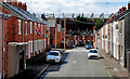
Runnymede Drive, Belfast
A street of terrace houses, running off Tate’s Avenue. Windsor Park football ground is in the background.
Image: © Albert Bridge
Taken: 10 Aug 2010
0.02 miles
2
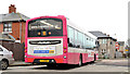
Bus, The Village, Belfast
A Metro Wrightbus-bodied Volvo (902 KFZ 9902), calling at the stop in Tate’s Avenue, with the 11.43 Park Centre – Wellington Place (service 91 – running every hour).
Image: © Albert Bridge
Taken: 30 Jan 2014
0.03 miles
3
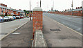
Tate's Avenue, Belfast (3)
See Image The western end of Tate’s Avenue, looking towards the Lisburn Road, showing the original line (left) below the present line.
Image: © Albert Bridge
Taken: 4 Jul 2010
0.05 miles
4
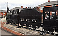
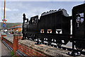
Train sculpture, Belfast (1)
A sculpture, on the northern side of the Tate’s Avenue bridge (Glenmachan Street end), depicting a train from the Victorian era. By David McClelland, it is part of the “Re-imaging Communities” project Image
Image: © Albert Bridge
Taken: 29 May 2011
0.05 miles
5
Train sculpture, Belfast (2)
See Image A similar one on the other (southern) side.
Image: © Albert Bridge
Taken: 29 May 2011
0.05 miles
6
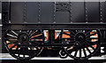
Train sculpture, Belfast (3)
A close look at the detail of the driving wheels of the 2-4-0 locomotive seen in Image
Image: © Albert Bridge
Taken: 29 May 2011
0.05 miles
7
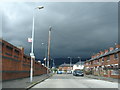
Tates Avenue Belfast
Thunder clouds on the way
Image: © Ronan Magee
Taken: 10 Jul 2008
0.05 miles
8
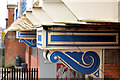
Ironwork detail, Tate's Avenue bridge, Belfast
Detail from the fancy ironwork on the northern side of the bridge. The name “Colville” is clearly visible at top right. I take this to be a reference to Colville’s of Lanarkshire http://myweb.tiscali.co.uk/steelworks/Colville's.htm. The Millfield Foundry, Belfast is represented too Image See also Image
Image: © Albert Bridge
Taken: 30 Jan 2014
0.05 miles
9
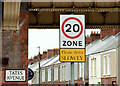
20 mph zone sign, Donegall Avenue, Belfast (March 2015)
A 20mph speed limit sign, beside Tate’s Avenue bridge http://www.geograph.org.uk/snippet/2337, at Donegall Avenue.
Image: © Albert Bridge
Taken: 7 Mar 2015
0.05 miles
10
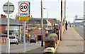
20 mph zone, Tate's Avenue, Belfast (December 2014)
A 20mph zone along part of Tate’s Avenue on the northern side of the bridge.
Image: © Albert Bridge
Taken: 4 Dec 2014
0.06 miles